The Accuracy of some Mediaeval Maps of the Taprobane Island
Gregor Reisch
Introduction
It had become evident to me, that the map of the island of Thile in the mediaeval manuscript Burney MS 111 is very consistent in relation to some coastlines, compared to the island of Tustna in
Norway. Therefore I came to the resolution to make a similar comparison with an island in the Indian Ocean, which is a well-known tourist destination. Namely Sri Lanka, or Ceylon, as it was
called among the British, or Taprobane, as it was called by Greeks in antiquity. The comparison had
to be carried out in this investigation especially for the coastlines and in the order of importance of
the cardinal points for ancient visitors from overseas, that is, from west to east. As generic terms,
the labels on the map for regions inhabited by population groups offered themselves.
The map of Taprobane was attached to the book Geographike Hyphegesis, “Geographical Guidance” by Klaudios Ptolemaios as panel XII on Asia. As is nowadays generally assumed, his original
text did not contain any maps. In view of the fact that Egyptian papyri could even contain coloured
drawings, it does not seem too far-fetched to assume that this was also the case with Ptolemy's text.
First of all, he wrote his works in Egypt at a time when ancient Egyptian culture had not yet disappeared from everyday life. Furthermore, at least in the Byzantine period, coloured illustrations were
added to his book.
Some modern authors have already tried to assign the places named by Klaudios Ptolemaios in his
text and on these maps to today's places. Among them were McCrindle in the nineteenth and Nicholas in the twentieth century. However, most of the surviving maps are very imprecise regarding the
coastline drawings, when compared to the coastlines of today's island Sri Lanka. What is special
about the map Burney MS 111 folio 102 versa in its Greek language is, that it is much more accurate than other maps of Taprobane in comparison with coastlines on today's modern maps. Interestingly, the map of Tabrobane in the back of this manuscript is also a more accurate one than the one
at the very front of it, numbered folia 1 versa. In the following, when speaking of Burney MS 111 in
this investigation, the more precise folio 102 versa is meant. With this map, it is much easier to find
out, how ancient seafarers used to call today's places in ancient times, even though the outdated
names of places often seem to us to say nothing or to be just curious.
One recognizes the aspiration of the Burney MS 111 cartographer to depict the island's contours
through basic geometric shapes, such as circular segments, trapezes and straight lines. The islands
around Taprobane have rather a schematically round shape, with small coves. All this leads to a
quite modern look, just as the visualizations on today's maps. The ancient cartographers were seriously concerned with the small islands, including their position to the mainland. This can be explained by the fact, that small islands served the sailors as important landmarks. Due to the position
of the islands and islets to the mainland on the ancient maps, harbour towns could be more precisely
targeted. For some of today's insignificant rocks off the coast, it seems that in earlier times names
like for real islands have been given. Thus, this map representation, in particular, has its current
counterpart in the “Sailing Directories Asia”, in which even the smallest island on the route can be
1
�The Accuracy of some Mediaeval Maps of the Taprobane Island
of importance. The fact that the presumably Byzantine cartographer of Burney 111 considered the
drawing to be more important than the inscription can be seen from two things. First, the letters of a
word are partially superimposed on each other in order to have more space for the drawing. And
secondly, place names were sometimes even partially covered by the painting. In view of the accuracy of the drawing of this map in the manuscript, it can rightly be described as a very good handwritten copy, as fine work.
Throughout the centuries, the entire accuracy of map representations of the island of Taprobane has
certainly suffered from the fact that these were always handwritten copies of copies. In addition, selective degrees of accuracy could develop, depending on which places the copyist had copied conscientiously, and which he did not. For example, regarding the islands surrounding Taprobane, the
map of Nicolaus Germanus sometimes offers more exact similarities with today's islands, than with
the ones from Burney MS 111. In addition, on Nicolaus Germanus map, in each compass direction,
the corresponding headland has contour lines, almost precisely drawn like on topographical maps of
today. Admittedly, such drawing work could have been done in ancient times by a simple seaman
on site. It did not require an artistic talent, but a good understanding of height differences and essential or insignificant objects, which could be seen in the landscape.
As settlements and landmarks with denominations, obviously preferentially located headlands on
the coast were depicted on the Taprobane maps. About the places in the interior of the island, the
people in the west seem to have known mainly from old texts and hearsay. For example, the name
Anuradhagrama had already been replaced by the name Anuradhapura centuries before Ptolemaios
wrote about it. But maps of at least five centuries were still available for Ptolemaios in the Library
of Alexandria.
Klaúdios Ptolemaîos, or Claudius Ptolemy as we usually call him, lived and worked between 100
CE and170 CE. He wrote about places on Taprobane at a time of lively trade between Roman Egypt
and today's Sri Lanka. As a kind of map for coastal sailors, Ptolemaios Taprobane followed the
same tradition as that of the Roman Pomponius Mela, who had written his book De Chorographia
libri tres one century earlier. This had summarized the knowledge about the coasts of the known
countries of the world, in the early days of the Roman Emperor Claudius. In the introduction to his
book, Pomponius had added the following text, which already reads like an introduction to the geographical work of Klaudios Ptolemaios:
To start with, in fact, let me untangle what the shape of the whole is, what its greatest
parts are, what the condition of its parts taken one at a time is, and how they are inhabited; then, back to the borders and the coasts of all lands [a] as they exist to the interior
and on the seacoast, [b] to the extent that the sea enters them and washes up around
them [...]”1
1
Pomponius Mela’s Description of the World, Book 1, passage 2, translated by F.E. Romer, Michigan 1998.
�The Accuracy of some Mediaeval Maps of the Taprobane Island
Galiboi Region
Fig 1 (top): North of Taprobane (Burney MS 111)
Fig 2 (bottom): Detail of a Map of Districts of Sri Lanka, with Northern District (Geographic Guide)
What is particularly noticeable on the Taprobane map of the Burney 111 manuscript is the complete
absence of the Jaffna Peninsula. It is as if this land area was taboo for seafarers or just too uninteresting for trade to be approached by ship. In fact, it is assumed that this area, which was known as
Nagadiba, in the 3rd century CE, was still inhabited by a group of people, distinct from the Sinhalese
and Tamils2, named Nagas. Even the Tamil king of the island in the 2nd century BCE, named Elara,
ruled the country from his residence in Anuradhapura, with its agricultural area, and not from the
water-scarce region of the Jaffna Peninsula.
It is odd, that on the Taprobane map, Nagadiboi is the name of a region, which can be located today
between the rivers Yala Oya and Mahaweli Ganga. An error or deliberate deception can be suspected. Therefore, what can be seen first lying on the map in the north is the so-called Galiboi region
(Fig. 1), which corresponds to today's Northern District of Sri Lanka. The region's most probable
name origin is from the Sinhala word Galibbā3, for the “fresh water tortoise”(Clough). This and the
mentioning of tortoises in relation to Taprobane by Pliny and in the Periplus in the 1st and by Aelian
in the 2nd century CE has, thankfully, already been referenced by Faller (Faller, p. 45/104/122).
2
3
The Sri Lanka Reader: History, Culture, Politics, page 73, by John Holt, Durham and London 2011.
Emys trijuga, today living only in small areas in Sri Lanka, as near Puttalam.
3
�The Accuracy of some Mediaeval Maps of the Taprobane Island
1. Talakori Port
Seen from the position on the map (Fig. 1), the Talakori port can be identified with the village,
which is called Tadduvankoddi today, being a small town at the stream Tadduvankodi Aru and lying opposite to the Elephant Pass Causeway. The Elephant Pass lies in the north of Sri Lanka
between the Jaffna Peninsula and the mainland. It separates the lagoon of Jaffna in the west from
the Chandikkulam lagoon in the east. Originally, the two lagoons formed a uniform water surface,
which reached its narrowest point at the Elephant Pass at around 1000 metres. Here the water was
so shallow that it could be crossed with elephants before the road connection was built. The Elephant Pass owes its name to this fact. The Talakori Port is located on the map east of the Borgana
Headland.
2. Borgana Headland
Fig. 3 (top): Borgana Headland from Nicolaus Germanus map of Taprobane
Fig. 4 (right): Topographic map of Pooneryn, rotated
right, what is an eastern view of it (Google 2018)
The next headland to the east of the Talakori port is called Borgana (Fig. 1) and supposedly the
Greek pronunciation of Pūnakarik in Tamil, named Punarin in Sinhalese, hence its English name
Pooneryn. That Tamil seafarers, who were surely from southern India, came also to Egypt can be
seen from Tamil-Brahmi graffito4, found at ancient seaports at the Red Sea, as Berenike. Therefore,
the adoption of the Tamil name in the West for this headland is not surprising.
The map drawn by Nicolaus Germanus (Fig. 3) provides the most accurate congruence in comparison to a modern topographic map (Fig. 4). Especially when the topographic map is rotated and thus
provides a view as if the observer was looking at the peninsula from the east. This may be due to
the fact, that the ancient seafarers had seen the form of the headland mainly from its eastern side,
and remembered and reported this view.
4
See, for example: The Making of Roman India, page 174, by Grant Parker, Cambridge 2008.
4
�The Accuracy of some Mediaeval Maps of the Taprobane Island
3. Galiba Headland
Fig. 6: Detail from Map of Ceylon from 1912
Fig. 5: Galiboi Region (Burney MS 111)
The Devils Point on the coast, with the surrounding area till the town Pallawarayankaddu, is supposedly the so-called Galiba Headland. The region of the island in the south of the headland has no
real mountains, as the Sinhalese word gal in the name Galiboi might indicate. It is more likely that
in ancient times western seamen found tortoises, Galibbā and Ibbā, in large numbers in this coastal
region and invented the myth of locals, who used tortoise shells as roofing due to the size of the
shells. In antiquity, the locals of this region may thus simply have been called "tortoise people", because of an assumed practice. At least, at Tennent's time in the 19th century, one of the world's
largest species of tortoises still lived in the Gulf of Mannar (Faller, p. 47/104).
The comparison of the map from Burney MS 111 (Fig. 5) and a British map of Ceylon, made in
about the year 1912 (Fig. 6), offers a very exact match regarding the coastline.
4. Kanathra Island
Fig. 7 (top): Islands of Ouangana and
Kanathra (Burney MS 111)
Fig. 8 (right): Map of the islands
Pamban and Mannar (Google 2017)
5
�The Accuracy of some Mediaeval Maps of the Taprobane Island
The Kanathra Island (Fig. 7) can be identified as the Mannar Island (Fig. 8). Probably this island reminded the mariners of a Greek type of chariot, made of wickerwork, and called Kanathra. In Sri
Lanka, there are traditional bullock carts, generally called karaththe. In the drawing of the island of
Kanathra from Burney MS 111, one believes to recognize such a car, just without wheels and oxen.
Ancient Greek traditions and Sinhalese traditions do not seem to differ much regarding the concept
of wickerwork chariot processions, as the following comparison illustrates:
“Hyacynthia (Ὑακίνθια), a great national festival, celebrated every year at Amyclae by the
Amyclaeans and Spartans [...] The festival was
called after the youthful hero Hyacinthus, who
evidently derived his name from the flower hyacinth (the emblem of death among the ancient
Greeks) [...] The Spartan and Amyclaean maidens, after this, riding in chariots made of wickerwork (κάναθρα), and splendidly adorned, performed a beautiful procession. Numerous sacrifices were also offered on this day [...]”5
“On poya days Buddhists visit the village
temple. […] villagers making preparations during the season of na mal to make the pilgrimage
to a well-known stupa a few miles away […] A
pilgrimage to offer na flowers to the Buddha is a
romantic day trip. The pilgrimage centers round
the decorated bullock cart, which traditionally is
the affordable means of transport available to
villagers. Flowers and other offerings are carefully packed along with a lunch for all. Women
sit in the cart, and the men walk behind it.”6
Interestingly, still in the year 2015, following a tradition that was revived after a long lapse, some
devout Christian Sri Lankan families began a 13-day long pilgrimage in a convoy of bullock carts
starting from the village of Mavila in Marawila to Mannar. They wanted to visit the Roman Catholic Marian shrine called “The Shrine of Our Lady of Madhu”.7 In conclusion, it can be said that
very old traditions have been preserved on Sri Lanka. The listed examples illustrate that not only
the graphic representation of Kanathra's outlines in Burney MS 111 is appropriate. Also in other respects, the naming, which Ptolemy reproduced, can hardly have taken place arbitrarily.
The Ouangana Island in the west of the Kanathra Island, probably pronounced Vangana, names the
South Indian Island of Pamban. The Ouangana Island shows, especially in its south-eastern part,
similarities with Pamban. This is Pamban's south-eastern tip, named Dhanushkodi, which literally
means “end of the bow” in Tamil.
5. Margana Port
This has to be the town called today Manthai or Mantai, called Mahatittha in ancient times. The
name Margana (Fig. 5) may be derived from Mannārama (Sinhalese), which today is only the name
of the town Mannar on Mannar Island. As the drawing indicates, the ancient fortification of the
harbour was not on Mannar Island, but on the mainland of Sri Lanka, in the area which is today
Manthai. Nicholas outlined the importance of the port of Mahatittha for trade and invaders in great
detail (Nicholas Chapter IX). Nicholas mistakenly identified Mahatittha with the Modountou Port.
However, the map from Burney MS 111, by the position of the town, leaves no doubt as to which
port was meant by the word Margana.
5
A Dictionary of Greek and Roman Antiquities, page 502, by William Smith, London 1842.
Buddha in Sri Lanka: Remembered Yesterdays, page 102, by Swarna Wickremeratne, New York 2006.
7
http://www.sundaytimes.lk/150419/news/with-faith-in-their-hearts-and-their-bullock-carts-devotees-make-trip-tomadu-145521.html
6
6
�The Accuracy of some Mediaeval Maps of the Taprobane Island
Anourogrammoi Region
Fig. 9: Anourogrammoi Region (Burney
MS 111)
Fig. 10: Detail from a modern map of
rivers of Sri Lanka
Before Anuradhapura was considered as a city, it was just the village of Anur̄dhagr̄ma (Sanskrit).
During the reign of the Sinhalese king Pandukabhaya in the 5th century BCE, it was renamed
Anuradhapura. Later seafarers seem to have retained the old name for a long time, as the name Anourogrammon (Fig. 9), given by Claudius Ptolemy, suggests. Nevertheless, the depiction on the
maps also shows the size and thus the importance of the place, which the travellers from the west
were well aware of. The name for the region, inhabited by the Anourogrammons, derived from it.
Although it is an inland settlement, the draughtsman of the map from Burney MS 111 has positioned it relatively exactly between the coastal town of Iogana, Anarismoundou Headland and
Galiba Mountain, compared to their counterparts on modern maps of Sri Lanka.
1. Iogana Port
The Iogana port (Fig. 9) drawn on the map, lies west of the inland city of Anorogrammon, and thus
probably near the mouth of the Modaragam Aru River of today. Possibly this port was the settlement named Magananakara, which was mentioned in two ancient inscriptions from Sri Lanka.
7
�The Accuracy of some Mediaeval Maps of the Taprobane Island
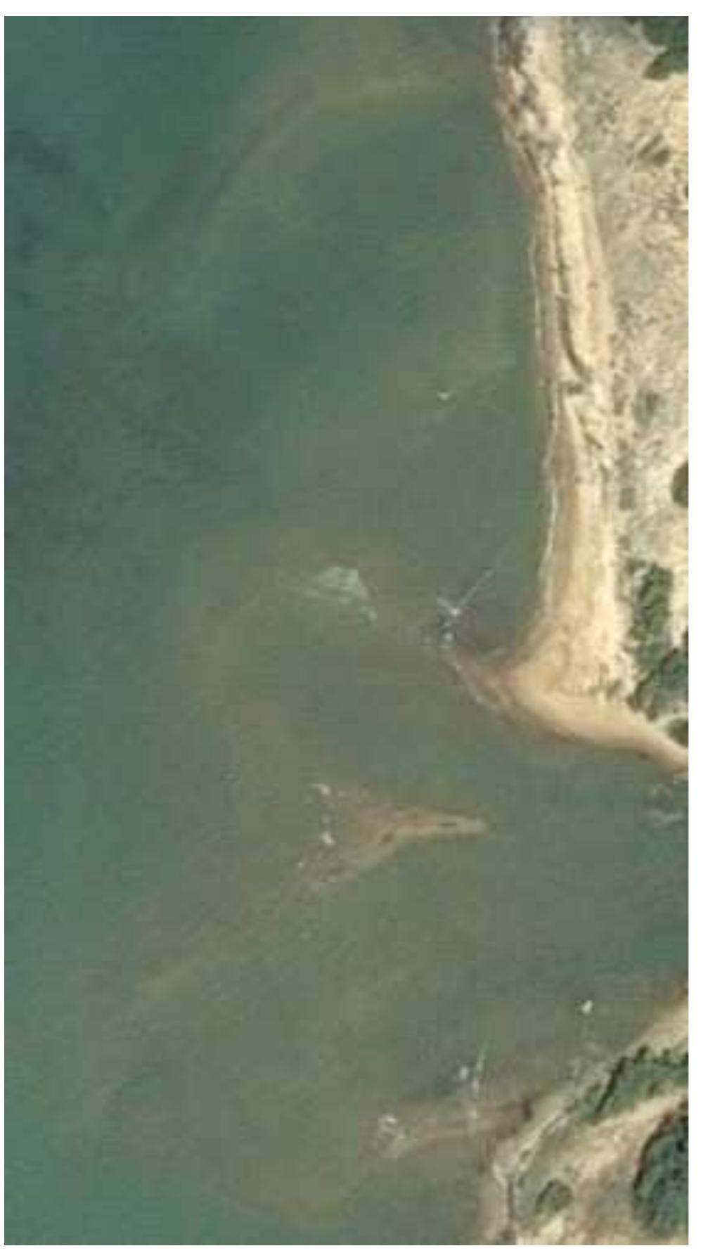
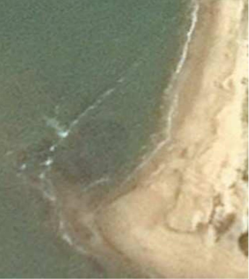
Fig. 11 (left): Aerial photo of 01/19/2015 of the coast
at the bay of the Modaragam Aru. North of the estuary is some rectangular structure on the strand and
circular arc in the water (CNES / Airbus 2017)
Fig. 12 (top): Detail of an aerial photo of 19.01.2015
of the coastline at the bay of the Modaragam Aru
river (CNES / Airbus 2017)
The satellite image of the coastline at the Modaragam Aru river bay (Fig. 11 and 12) seemed interesting enough to me, to be shown in this survey. One may only recognize the play of waves and
sand and see rock structures in the aerial photograph. But the question may also arise, as to whether
man-made structures are not very likely in this part of the coast. At least it can be assumed that in
older times, the Modaragam Aru River served as a busy waterway. Admittedly, this river is not
marked on any maps of Taprobane, which does not necessarily mean that it was insignificant.
Himanshu P. Ray wrote:
An early Brahmi inscription found in Sri Lanka at Andiyagala, on the northern bank of
the Modaragam Aru, records the construction of a flight of steps by a person who describes himself as “the mariner (navika) of Bhojakataka” (Paranavitana 1970, no. 105:
8). Bhojakataka has been identified with the site of Bhatkuli in central India.8
Furthermore, in the footnote to a Sinhalese medical manuscript from Paris, the author’s name of it is
given as Monaragammana Thera, respectively Mōdaragam mahathera or Mōragammana tera:
8
Himanshu P. Ray: “Interpreting The Mauryan Empire: Centralized State or Multiple Centres of Control?”, pages 13-51
of Ancient India in Its Wider World, edited by Grant Parker and Carla Sinopoli, Michigan 2008.
8
�The Accuracy of some Mediaeval Maps of the Taprobane Island
Monaragammana being really the native place of the Buddhist monk.[21] The same
verse describes this place as a famous city (paṭuna, Skt. paṭṭana, Tamil paṭṭanam). This
was probably on the river Mōdaragam ̄ru in the Gulf of Mannar9.
2. Anarismoundou Headland
The so-called Anarismoundou Headland (Fig. 9) has to be found at Kudiramalei Point, its name said
to be derived from Tamil for “Horse Mountain”. McCrindle identified Anarismoundou Cape also
with Kudramali Point. Anarismoundou could be derived originally from a Sanskrit form of this
meaning. For example, adopted from Assamahīdra, via its Pali form Assamahinda to Anarismondou.
3. Aegidion and Orneon Islands
Fig. 13 (top): The islands of Aegidion and Orneon
(Burney MS 111)
Fig. 14 (right): The islands of Baththalangunduwa and Vella on
a satellite image of 12/31/2004 (Image Landsat / Copernicus on
Google Earth)
Off the cost, at the latitude of the Anarismondou Headland, lie the islands of Aegidion and Orneon
(Fig. 13). These can be identified with the populated island Baththalangunduwa10 and a sandy island
south of it, named Vella (Fig. 14). Both stretched islands can very well be seen from the Kudiramalei Point. Aegidion can be translated from Greek, meaning “goat kid” and Orneon comes from
the Greek word for “bird”. Maybe the inhabitants of Baththalangunduwa used to keep goats11. On
the Kalpitiya peninsula, it is still a tradition to let these animals roam free12. It is also said, that in
this area are thousands of sea gulls, pelicans and other birds looking for preys and can be watched.
On Vella are good wind conditions for kite sports. This is a detail that used to be important for sailing ships in the past.
9
Jinadasa Liyanaratna about the text Yogaratn̄karaya in Medical Literature from India, Sri Lanka, and Tibet, page 87,
edited by Gerrit Jan Meulenbeld, Leiden 1991.
10
A personal blog report from the island can be found at
http://sri-lankan-travelogue.blogspot.de/2014/09/battalangunduwa-baththalangunduwa.html (14.01.2018). The island is
known today for its dried fish.
11
Modern goat farming in the dry zone of Sri Lanka, as Puttalam, is discussed in the paper “Improving Goat Production
in the 'Coconut Triangle' of Sri Lanka”, AGRIEAST(1999), Vol. 1, No. 1, pp. 67-74. Interestingly, the words for the
ancient Sinhala language and goat are almost identical, Eḷuwa and Eḷuw̄ (Clough, page 87).
12
See, for example, http://www.srilankamirror.com/news/4254-animal-cruelty-in-kalpitiya-video (14.01.2018).
9
�The Accuracy of some Mediaeval Maps of the Taprobane Island
Soanoi Region and Sindokanda Region
Fig. 15 (top left): The Soanoi and Sindokanda Regions
(Burney MS 111)
Fig. 16 (top right): (Google Maps 2017)
Fig. 17 (bottom right): Detail from Sri Lanka river map
(Free licence 2013)
The Soanoi Region on the map names the Kalā Oyā region. Especially this illustration (Fig. 15)
from Burney MS 111 shows the high accuracy of this map, astonishing in regards to the time of creation. In comparison with a modern map (Fig. 16), it is almost identical in terms of the coastline.
1. Soanas River
It was already obvious for Nicholas, that the Soanas River is the Kalā Oyā of today. He recognized,
that the River Soana is the Gona-nadī, the ancient name for the Kalā Oyā. So the Soanoi had to be
the inhabitants of the Gona district on the lower course of the river (Nicholas, p. 12). Somewhere
along its upper course, there has been charted a town called Podouka. What we know about the area
in antiquity is that, around the year 91/92 CE, King Cūlabhaya had the Cūlagallaka monastery built
on the banks of the river, which means Little Gallaka monastery (Mahavamsa XXXV 13). Later the
king Aggabodhi II is said to have had built in the 7th century CE a Padh̄naghara, attached to the
monastery, what is a dwelling place for meditating monks (Cūlavamsa XLII 49).
On the map from Burney MS 111, the river bends (Fig. 15) were reproduced in great accordance
with reality, compared to a modern map (Fig. 17).
10
�The Accuracy of some Mediaeval Maps of the Taprobane Island
2. Monakhe and Ammine Islands
Fig. 18: Monakhe and Ammine Islands in relation to the mainland (Burney MS 111)
Fig. 19: “ammina” Island and
the erased neighbouring island,
in relation to the mainland
(Nicolaus Germanus)
Fig. 20: Ammina
Island in relation to
the mainland
(M. Servetus)
Fig. 21: Islands
of Ambanttativu
and Mattutivu,
in relation to the
mainland
(Google Maps
2017)
11
�The Accuracy of some Mediaeval Maps of the Taprobane Island
On the Taprobane map from the Burney Manuscript, the two islands Monakhe and Ammine were
drawn side by side (Fig. 18), positioned west of the Sindokanda Haven. In the Manuscript of Nicolaus Germanus an erasure of Monakhe is visible at this position (Fig. 19), and a placement of the
island further south. A puzzling change, that was also adopted on later maps, as on the map from
Lyons by Michael Servetus, from the year 1535 (Fig. 20). This map no longer originates from the
time of manuscripts, but book printing.
Fig. 22: Ammina Island on the map of M. Servetus
from 1535 (Paulus Swaen)
Fig. 23: Ambanttativu on 3/11/2011 (Digital Globe
2017)
Ammine can be identified with Ambanttativu, whose form even resembles that of Ammina on the
map of 1535. This map by Michael Servetus again shows the peculiarity, that for the island of Ammine, in Latin Ammina, the contours seem to have been reproduced particularly accurately. The
other islands on Servetus depiction of Taprobane have an admittedly rather random pancake shape.
Ambanttativu is especially characterized by its V-shape (Fig. 23). Even the green colouration of the
island on this map is in line with reality, as Ambanttativu is still heavily wooded13. And the horizontal lines, surrounding the island on the map, could even indicate the direction of the water flow.
On a modern map you can see, that east of Ambanttativu there also lies another island off the mainland (Fig. 21), named Mattutivu. This island, called Maddu doova in Sinhalese, is possibly synonymous with Monakhe.
Both islands of today are also situated opposite Kalpitiya with its peninsula. It is said that Ambanttativu has its name derived from the Sanskrit word for “attached” or “nearby” since it is located approximatively 350 m from the mainland. The name Monakhe on the old map could itself derive
from the Greek word monakos (μονάχος), which means “alone”, in the sense of “without company”, or “individually”. In Sinhalese in turn, Maddu means “in the middle”, namely between Kalpitiya and the mainland. Comparing it with the island on the map from Burney MS 111 (Fig. 24),
Mattutivu’s (Fig. 25) outlines seem to have been mistakenly assigned to Ambanttativu.
One thing can already be said in summary after comparing the different maps of Taprobane.
Namely, that there seems to have been most confusion among the map copyists, drawing the island
13
A description of the islet on http://islandsofsrilanka.blogspot.de/2014/05/1-ambanttativu-island.html (01/21/2018).
12
�The Accuracy of some Mediaeval Maps of the Taprobane Island
of Taprobane, in regards to the two surrounding islands of Monakhe and Ammine.
Fig. 24: Ammine Island (Burney MS 111)
Fig. 25: Mattutivu Island on an aerial photo of
10/27/2005, as seen from a western direction
(DigitalGlobe 2018)
3. Sindokanda Port
The name Sindokanda (Fig. 15) seems nowadays puzzling for the locality of Karative, respectively
Karaitivu, or Serakkuliya (Fig. 16). Linguistically, a native Sinhalese word is very likely to be the
origin of the name. Actually, Sindokanda seems to be derived from a Sinhalese word. Perhaps from
the composition of siṇdu, for “horse” or “sea” and kanda, for “hill”. This would have the meaning
of an elevation, called “Horsehill” or “Seahill”, which would have been easily recognizable on the
flat coast for the mariners.
4. Priapios Haven
Stripes of land lying in front of bays, such as those of the Kalpitiya peninsula and Panumugama,
were apparently simply omitted on the Taprobane maps, for the sake of schematic simplicity.
Though Kalpitiya seems to have been a landmark for the sailors in the old days, with a particular
importance for navigation. The name Priapios Haven (Fig, 18) probably was created from an association by mariners of the Kalpitiya peninsula with the phallus of the fertility god Priapos. According
to Greek mythology, Aphrodite had a love affair with Dionysos. In the coastal region of Abarnis
near Lampsakos, she bare him a son, named Priapos. The western mariners, who came to
Taprobane, must have seen themselves confirmed in their association, by the worship of Lingas in
local Hindu temples on the mainland. The Priapios Haven of antiquity must have covered the southern part of the Puttalam Lagoon with its favourable anchorages.
Buddhist places of worship, at least known to native mariners, were located also not far from this
coastal stretch. About 15 miles southsouth-east of Puttalam, inland in the village of Tonigala, two
rock inscriptions of the 1st century BCE were discovered. In these, the gifts of a cave and a cistern
to the Buddhist Order were recorded by an “envoy-mariner” and “daring mariner” (Paranavitana
1054 and 1055; Somadeva, p. 57).
13
�The Accuracy of some Mediaeval Maps of the Taprobane Island
Boumasanoi Region
Fig. 26 (top): The Boumasanoi Region
(Burney MS 111)
Fig. 27 (right): A modern map of the Colombo
Area (http://map.openseamap.org/ [01/21/2018])
The name of the region Boumasanoi (Fig. 26), which the seafarers used for their inhabitants, is
probably derived from bhūma, for “land/country” and sana, for “ancient”, from Sanskrit. As Nicholas already noted, the Boumasanoi occupied the ancient Kälaṇiya kingdom (Nicholas, p. 13).
Oral legend probably already identified Kalȳni in ancient times with a place from the legendary
tale Ramayana, where in mythical times the successor of the Yaksha king Ravana is said to have
been crowned as new king of the island14. In addition, according to a later legend, Gautama Buddha
is said to have visited the place with its Yakkha king (Mahavamsa, I. 71-77). In both lores, the original ethnic group of so-called Yakshas inhabited the region. This would explain why this region
could later be considered as “ancients country” by visitors from abroad.
What is noticeable, when comparing the maps, is that the coastal section between the Dios Headland and the Noubartha port has been depicted very briefly (Fig. 26). This indicates that there were
no noteworthy long-distance trading ports on this route in Graeco-Roman times.
1. Anoubingara Port
This ancient port can be the identified with the modern port of Negombo (Fig. 27). Today, there is a
Buddhist temple in Negombo popularly known as “Angurukaramulla Temple”. The name derives
14
This episode can be found in: “Vibhishan Consecrated”, Canto CXIV of The Ramayan of Válmíki translated into
English verse by Ralph T.H. Griffith, p. 493/494, London 1895.
14
�The Accuracy of some Mediaeval Maps of the Taprobane Island
possibly from the Sanskrit word angāra for charcoal. Anoubingara could be a Greek variant of the
name Angurukaramulla.
2. Prasodaes Bay
The ancient Prasodaes Bay has to be the Negombo Lagoon (Fig. 27) of today. Nicholas also wrote
that it may be the Bay of Negombo (Nicholas, p. 12). The Bay of Negombo is also shown on the
maps without the typical narrow, offshore coastal strip, that characterizes the lagoons of Sri Lanka.
The name Prasodaes is obviously of Greek origin. There exists, for example, a beach named
Prasoudi on the Greek island of Corfu, with a sandy shore and a length of two and a half kilometres.
Possibly the long Bay of Negombo reminded the Greeks of this coast of Corfu. The naming Prasoudi is said to come from the plant prasoulida (chive) which grows on the cliffs a few meters
above the shore. A related possibility of name origin for Prasodaes is the word πρασώδης for "leekgreen, blue-green". It could have been meant by ancient seafarers as an indication of seaweed,
which still grows today in the Negombo Bay15, but also at other parts of the coast of Sri Lanka.
3. Dios Headland
The Dios Headland (Fig. 26) refers to the godfather Zeus, and seen from the position on the map
from Burney MS 111, it is the city area of Colombo of today. McCrindle also identified the Cape of
Zeus with Colombo. As Nicholas did too, writing that the Headland of Zeus had to be the promontory of Colombo. The fact, that this landmark was associated with the highest Greek god, indicates
that the importance of the area was known, having an allegedly ancient royal residence.
4. Noubartha Port
The Noubartha Port (Fig. 28) is known to us today, as the small port Beruwela. McCrindle identified Noubartha also with the then so-called Barberyn. According to Mills it was formerly also called
Barawali (Mills, page 334). He wrote: “It has an anchorage for ships, and is safe for boat landing,
even in the south-west-monsoon.” So the Chinese used it as their base in Ceylon on six expeditions
in the 15th century (Mills, page 334). The map from Burney MS 111 was created around the beginning of the 15th century and that of Nicolaus Germanus around the year 1467. Also at the same
period, a Chinese voyager and translator called Ma-Huan accompanied the Admiral Zheng He on
three of his seven expeditions to the Western Oceans. The book about his voyages, including the
one of 1421 to Ceylon, he finished about 1451. The Chinese gave the places off the coast their own
meaningful names, too. Thus, we have from this period several written records about the coast of
Taprobane, respectively Sri Lanka.
5. Karkos, Phelikos and Irene Islands
The position of the islands in relation to the Noubartha Port leaves no doubt that these are the islands off the coast of Beruwela.
15
A paper by Dr. H.B. Jayasiri and Dr. Sisira Haputhantri of the “National Institute of Oceanography & Marine Sciences” (NARA) says: “[…] the lagoon is characterized by a brackish water flora (seaweeds) and some mangrove forests
in the northern part.” on page 1 and at https://www.cbd.int/doc/meetings/mar/ebsaws-2015-01/other/ebsaws-2015-01template-srilanka-en.pdf (04/17/2018).
15
�The Accuracy of some Mediaeval Maps of the Taprobane Island
The Greek word Koraki (κοράκι on Fig. 28) means crow in English. Phelikos (Fig. 28), is the Greek
version of the Latin name Felix, for English “luck”. And Irene (Fig. 28) or irena (Fig. 29) are derivations of the Greek word Eirene (εἰρήνη), for “peace”. Luck and Peace probably refer to the port of
Beruwela (Fig. 30), which was considered to be lucky for seafarers, who found a quiet anchorage
here.
Koraki itself is obviously the Crow Island of today (Fig. 30). Phelikos has to be the Barberyn Island
(Fig. 31), and Irene is a nameless rock islet (Fig. 31) off the coast of Beruwela.
Today, on Barberyn Island stands a lighthouse and the surface is covered with tall coconut palms.
Green coloured is also the painting of the philenis Island (Fig. 29) on the 15th century Latin map of
Nicolaus Germanus. The island of Barberyn is called Welmaduwa Island by the natives (National
Geospatial-Intelligence Agency).
The island Barberyn has its name originally from the port Barberyn, which itself was possibly
called P’o-chi-li by the Chinese in the 8th century, Pervily or Pervilis by the Italian Giovanni de'
Marignolli, after his personal visit in the 14th century, and again by the Chinese, Pieh-lo-li in the 15th
century (Mills, page 333). All these names sound conspicuously similar to Phelikos or philenis.
Interestingly, the illustrations of philenis and irena by Nicolaus Germanus show very large similarities, also in colour, with modern satellite images taken during the springtime. Incidentally, Nicolaus
Germanus wrote names on his map usually in lower case, what is adopted in this study for accuracy.
Fig. 28 (top): Karkos, Phelikos and Irene Islands
(Burney MS 111)
Fig. 30 (top): Aerial view of the Beruwela area
(CNES/Airbus)
Fig. 29 (bottom): Islands of philenis and irena
(Nicolaus Germanus)
Fig. 31 (bottom): Aerial view of the 3/26/2014 from
Barberyn Island (CNES / Airbus) and to the right of
it an aerial photo of the 4/27/2015 from the island in
front of the Amuura Beach (Digital Globe 2017)
16
�The Accuracy of some Mediaeval Maps of the Taprobane Island
Rogondanai Region
The name of the Rogondanai region has very early been identified by modern authors as that of the
ancient island province called Rohaṇa, or Ruhuna. Nicolaus Germanus named it Rogandini and Servetus Rhogandani. At Klaudios Ptolemaios time, the foundation of the southern sub-kingdom of the
island Lanka, called Ruhuna, was already about 350 years ago.
A large number of coins from antiquity found in the Rohana region, speaks for the outstanding importance of this remote part of the island in the African-Asian trade network (Walburg, p. 288).
1. Kalandadrouna Island
Fig. 32 (top): Kalandadrouna Island
(Burney MS 111)
Fig. 34 (top): Map of Yakinigeduwa Island (Google
Maps 2017)
Fig. 33 (bottom): Calandadrua Island
(Nicolaus Germanus)
Fig. 35 (bottom): Yakinigeduwa Island on 2/8/2012
(Digital Globe 2017)
Regarding its position, the Burney MS 111 cartographer seems to have seen Kalandadrouna Island
no longer as belonging to the Boumasanoi region, but to the Rogandanai region. Kalandadrouna Island (Fig. 32) can be identified with the island today called Yakinigeduwa (Fig. 34), at the mouth of
the Goviyapana River. As the website lk.geoview.info informs us, the estimate terrain elevation
above sea level of Yakinigeduwa is 1 metre and another name for this island is Katukurundu16
16
See http://lk.geoview.info/yakinigeduwa,1222964 (01/21/2018).
17
�The Accuracy of some Mediaeval Maps of the Taprobane Island
The name Yakinigeduwa for the tiny rocky islet (Fig. 35), means home of the she-devil. The other
designation Katukurundu was most probably because of the endemic so-called Katukurundu tree or
shrub, which was formerly used for fences (Clough). Trees on the island are said to be 40 m high
(2005). Moreover, it is said: “A prominent reddish cliff, 21 to 30m high, projects from the coast
about 0.6 mile W of the islet.”(Prostar Sailing Directions 2005, page 84). Perhaps this explains the
violet colouring of the island by Nicolaus Germanus. (Fig. 33). The Sailing Directions paper of
2015 tells us, that the islet forms a valuable mark in the surrounding low land.
2. Azanos River
Fig. 36 (top): Azanos River, Hodoka Haven and Orneon Headland (Burney MS 111)
Fig. 37 (bottom): Area between Polwatta Ganga, Mirissa and Dondra Head on a modern map (Google Maps)
18
�The Accuracy of some Mediaeval Maps of the Taprobane Island
The Azanos River (Fig. 36) is actually the Polwatta Ganga, as can be seen by comparing the Burney
map with a modern map (Fig. 37). The name Azanos could be of African origin and been given to
the river by African-Arab sailors17. Pliny the Elder mentioned an "Azanian Sea" (N.H. 6.34) that
began around the emporium of Adulis. In the Periplus of the Erythraean Sea, from the late 1st century CE it is said about Taprobane: “[...] and the southern part[of the island] trends gradually toward
the west, and almost touches the opposite shore of Azania."(Periplus 61). That there existed some
trade relations between the port of Adulis, lying in the "Azanian Sea", and Taprobane in ancient
times can be seen in a report by Kosmas Indikopleustes from the 6th century CE. A Roman merchant named Sopatros had travelled to Taprobane some decades earlier, with the help of seamen
from Adoulis (Faller, p. 159).
On the Taprobane map, you can find the region Elephanton nomai with the city of Olisoada on the
upper reaches of the Azanos River (not shown here). Tamed elephants could also have been a valuable commodity of the island in ancient times.
3. Hodoka Haven
The word Hodoka (Fig. 36) is probably also connected to an Arab name, given by Arab navigators.
This can be concluded, for example, by the following text: “’The last of these islands is Serendīb, in
the Sea of Horkand; it is the chief of all; they give the islands the name of Dībajāt’ (i.e. Dības).”18
The Arab term Horkand could have had become the word Hodoka in Greek. Hodoka was thus possibly a haven, which was already in usage for overseas trade with Arabia before Greeks managed to
disclose the secret of the monsoon. Judging by the position on the map from Burney MS 111, the
ancient haven lay somewhere near the Mirissa Fisheries Harbour of today.
4. Orneon Headland
The “Bird Headland” (Fig. 36) may have been a name given by some sailors for the Dondra Head
(Fig. 37). Dondra Head is the southern extremity of Sri Lanka. At this site, the Dondra Head Lighthouse stands now. “Dondra” is a European abbreviation of the ancient Sinhalese name “Devundara”
or Devanagara. In prehistoric times, before humans took possession of the headland of Dondra,
many more birds may have brooded there19. As Nicholas wrote about the Matara District: “The
coastal region may have been sparsely populated in early times, but the interior was not opened up
and settled much before the 10th century.”(Nicholas, page 70). This suggests, that the original map
from Burney MS 111 was drawn before that time.
In 1410 then, on behalf of the Chinese Emperor, an offering was made at Ta fo t’tang, translated as
“Great Buddha hall” (Mills. Page 331), what is Devinuvara. This we know from a trilingual slab inscription recorded in Chinese, Arabic and Tamil (Nicholas, page 70). So at least, at that time there
was already a Buddhist place of worship in Dondra. And three important ethnic groups, who dealt
with long-distance trade and left traces on the island of Lanka, were mentioned in this way, too.
17
On the probable African origins of the name Azania see John Hilton: “Azania - Some Etymological Considerations”,
in Acta Classica, Vol. 35 (1992), pp. 151-159.
18
Hobson-Jobson – The Definitive Glossary of British India, page 336, by Henry Yule and A. C. Burnell, Oxford 2013.
19
About the bird species of today see “The Study of the Faunal Diversity In Matara District – Southern, Sri Lanka”, by
the Wildlife Conservation Society in Galle from December 2009, downloadable at
http://www.wildlife.lk/data_files/downloads/Matara_BD.pdf
19
�The Accuracy of some Mediaeval Maps of the Taprobane Island
5. Arana Island
Fig. 38 (top left): Arana Island near “Birds Headland”
(Burney MS 111)
Fig. 39 (top right): Aerial photo of Paravi Duwa of 2/24/2006
(Digital Globe 2017)
Fig. 40 (bottom): Modern map of the area between Paravi
Duwa and Dondra Head (Google 2018)
The comparison of the drawing of Arana from Burney MS 111 with a modern aerial photo shows
great similarities in terms of the shape of the island's small coves. In contrast to reality, these are
only drawn with a stronger shaping.
20
�The Accuracy of some Mediaeval Maps of the Taprobane Island
The offshore island Paravi Duwa (Fig. 39) near Matara, could be the island named as Arana on the
Burney map. Matara itself is said to have been formerly called Mahathota. Even though the district
of Matara was probably scarcely populated during Ptolemy's time, it later seems to have become of
great importance for maritime trade. This is at least suggested by many late antique coin finds from
here (Walburg, p. 290). Translated, Paravi Duwa means as much as Dove Island, from Sinhalese
Paraviya, for dove or pigeon. Sri Lanka nowadays still hosts several pigeon species20. On the
Taprobane maps, this small island is located below the bird headland (Fig. 38). Modern maps show
that the island is situated en route when sailing from west to east towards Dondra Head (Fig. 40).
This makes it clear, that the positions of the islands in relation to the mainland on the Taprobane
maps only had to represent geographical proximity to the next stage point. They did not necessarily
have to reflect the compass direction, in which islands lay to the mainland. In ancient times, compasses may have been known, but not common.
That people, living in the western world in ancient times, were well aware of the importance of the
small islands surrounding Sri Lanka, which were often populated by birds, for the sea trade routes,
can be deduced from two Greek texts. Nicephoros Blemmydes, writing in the 13th century CE, and
an anonymous author correspondingly mentioned therein an obvious oddity. Namely, that birds
from the uninhabited islands around Taprobane would carry cinnamon leaves to Arabia (Faller,
2000)21. Both authors had obviously only expanded a fable by Herodotos from the 5th century BC
with a small additional information. In his archaic version he had once truly told an incredible tale:
As for cinnamon, they gather it in an even stranger way. Where it comes from and what
land produces it they cannot say, except that it is reported, reasonably enough, to grow
in the places where Dionysus was reared. There are great birds, it is said, that take these
dry sticks which we have learned from the Phoenicians to call cinnamon and carry them
off to nests stuck with mud to precipitous cliffs, where man has no means of approach.22
Then follows an even more fabulous story of how the Arabs snatched away the Kinamomon from
the birds, until it says: “[…] and then the Arabians come and gather them up. Thus is cinnamon
said to be gathered, and so to come from Arabia to other lands."
All this was most likely a poetic circumscription of the actual barter taking place with a local population, for the purpose of purchasing cinnamon sticks. Strabon had already seen a connection
between the ancient East African port of Daphnus, a so-called "cinnamon producing region", and
the southern Taprobane when he wrote his Geography at the beginning of the Christian era (Faller,
p. 42/43). Due to the fables related to Taprobane, one can assume that the district of Matara was
also an important destination for Arab traders seeking for spices. At least, at the start of the 21st century, cinnamon cultivation had concentrated along the coastal strip from Negombo to Matara.23.
Since time immemorial, Arab merchants in flowery language and in half-true seaman's yarn may
have obscured the emporiums from which they actually obtained sought-after spices, in order to
keep away potential competitors.
20
A list can be found at http://feathersofsrilanka.lk/category/pigeons-doves/ (01/19/2018). (01/21/2018).
See Faller's reproduction of the Greek texts on page 167 and his remarks on page 168 of his book.
22
History, Book III 111, in the translation of Herodotus, with an English translation, by A. D. Godley. Cambridge 1920.
23
“Cultivation and Management of Cinnamon”, by J. Ranatunga, U. M. Senanayake and R. O. B. Wijesekera, in Cinnamon and Cassia – The Genus Cinnamomum, Chapter 4, page 9, Boca Raton 2003.
21
21
�The Accuracy of some Mediaeval Maps of the Taprobane Island
Nanigaroi Region
The Nanigaroi region certainly bears a local name in a Greek pronunciation. On the map of Nicolaus Germanus, it was named nanigri, on Servetus map Nanigeri. There are interesting passages in
the story of the levying of the warriors against the Tamil invader Elara in the 2nd century BCE.
They're giving us a clue, where the name Nanigaroi could have originated. Examples were handed
down in the Mahavamsa: “In the village Nichchélawittiko, in the Giri division (of Róhana), one
Mahanágo had a son possessing the strength of ten elephants.”(Turnour, page 140) or “In the region
named Giri, in the village Niṭṭhulaviṭṭhika, there lived a son of Mah̄n̄ga strong as ten elephants.”
(Geiger, Mahavamsa XXIII 49). The original word for Giri division or Giri region is Girijanapada.
The Sinhalese Thupavamsa is talking about the Girinil province (Berkwitz, page 171).
Nicholas also wrote: “Giri-janapada, also called Girimaṇḍala, Girinil-danaviya and Giruv̄hōbaḍa,
was a district which extended in pre-Christian times over, approximately, present Giruva Pattus,
East and West.” (Nicholas, page 68).
Fig. 41: The Dagana “Sacred to the Moon” port, Korkobara port and Dionysoupolis (Burney MS 111)
Fig. 42: Coastal area between Dikwella, Godavaya and Kirinda on a topographic map (Google 2018)
22
�The Accuracy of some Mediaeval Maps of the Taprobane Island
While Girinil, for example, has simply the meaning of “Giri region”, the word Nanagaroi, or nanigri
or Nanigeri on the maps of Taprobane should most likely say, that this is “the region of the Giri inhabitants”.
1. Dagana “Sacred to the Moon” Port
The port Dagana (Fig. 41), which was said to be sacred to the moon, probably lay in the area
between Nilwella and Dikwella (Fig. 43). Here are several half-moon shaped bays, like the Dickwella Bay. The foreign seaman in ancient times will have seen this and thought that this was special
and could serve as a good landmark, which could also be recalled easily.
Fig. 43: Coast between Dikwella and Nilwella on a modern map (Open Sea Map 2018)
2. Korkobara Port
Korkobara (Fig. 41) may have been an ancient name for Godawaya, where near was found the famous Godavaya shipwreck (near the coastal area of Fig. 42). The ancient Buddhist monastery is
called the Goṭhapabbata Vih̄ra. The harbour was called in inscriptions Goḍapavata (Falk, 2001).
This name originates from goḍa for short and round and pabbata for a rocky mountain. Possibly
there was also a Sinhalese version of the name, as the compound word Koṭaparvata (Clough, pages
133 and 324), that means the same as Goḍapavata and was pronounced by the Greeks as Korkobara.
3. Dionysoupolis
The town of Dionysoupolis (Fig. 41) near the coast has in its name a reference to the Greek god Dionysos. In Latin, this place was called Dionysi seu Bacchi Oppidum - ‘The Town of Dionysus or
Bacchus’. Some of the other editions of Ptolemy's Taprobane have a coastal landmark called
Dionysi Promontorium - ‘The Promontory of Dionysus’. Both locations could have meant the ancient port of Kirinda (Fig. 42), which was connected with the ancient city of Mah̄ḡma by the
Kirinda Oya river. That the inland city north of Dionysoupolis with the name Nakadouma could
mean Mah̄ḡma seems plausible. Nicholas wrote about Nakadouba, that it was probably referring
to the N̄gam̄hathūpa, the largest thūpa of Mah̄ḡma (Nicholas, page 13).
Dionysos was equated by the Romans with Bacchus. And in the case of the Roman encyclopedist
Pliny the Older, he did report, that a Roman freedman had met the king of the island, dressed as
Father Liber (Pliny NH. 6.24), in the 1st century CE. Father Liber is a Roman synonym for Bacchus.
23
�The Accuracy of some Mediaeval Maps of the Taprobane Island
The Greeks and Romans probably associated the royal dignity in Indian culture with Dionysus in
general and Mah̄ḡma was, in fact, a royal residence.
4. Baasa Island
The Baasa Island (Fig. 44) lies south of the Dagana Haven on the Taprobane map. Probably this is
the so-called Blue Beach Island (Fig. 45) at Nilwella of today. The word Baasa may be derived
from the Sinhalese word bāsa, to shine. The Sinhalese noun Bāsuru means Sun (Clough, p. 421) so
that the island could simply have been called the “Sun Island” in former times. The outlines of the
islet, having a southern and (South-)eastern point, were depicted very well on the map from Burney
MS 111.
Fig. 44: Baasa Island (Burney MS 111)
Fig. 45: “Blue Beach Island” (Google Maps 2017)
5. Balaka Island
The Balaka Island lies south of the Korkobar Haven. Possibly this named one of the two so-called
Kahandawa Rocks, which is above water (Horsburgh, page 561). The name Balaka may have been
derived from the Sinhalese word Balaksha, literally “power to destroy”, and having actually the
meaning of (the colour) white (Clough, p. 413).
6. Alaba Island
Alaba Island lies south of Dionyosis Haven and is not coloured, that means it is white, on Nicolaus
Germanus map. Probably this is the Ibh̄ Rock, which was already in earlier times said to be very
dangerous, since being very little under water (Horsburgh, page 561).
It is also important to pay attention to it, following modern manuals for sailing: “Ibha Rock, with a
depth of less than 1.8m, lies about 0.8 mile SSE of Godawaye Point; it is steep-to and the sea does
not always break on it.” (Sailing Directions, Page 86).
In fact, there are satellite images in Google Earth™, that show how white foaming spray breaks
over the rock and makes it look like an island. As on images of 10/07/2005 and 6/21/2011 (DigitalGlobe). Or, as it appears on other satellite images, in calm seas, as inconspicuous colouration in the
water.
24
�The Accuracy of some Mediaeval Maps of the Taprobane Island
7. Barakes River
Fig. 46 (top): The Nanigaroi region with the Barakes River,
Zaba Island, Kaetaion Headland
and Goumara Island
(Burney MS 111)
Fig. 47 (bottom): The coast of
Ceylon with the Kumbukkan
Oya, Little Basses, Akasacetiya
(not written) and Great Basses
on a map from 1912.
Barakes (Fig. 46) may have been a foreign name for the Kumbukkan Oya, also known as Kumbukkan Aru24 (Fig. 47). In ancient times, the river was also called Kubukanda nadī (Nicholas, p. 23)
on the island. Kumbuk-kandēgoda was the name of a rata, a country district, in the Ruhunu Kingdom (Somadeva, p.65). Walpola Rahula postulated that some of the earliest settlements in the island
were distributed between the area bounded by the rivers Valaweganga and the Kumbukkan-oya
24
http://lk.geoview.info/kumbukkan_oya,1238323 (01/21/2018).
25
�The Accuracy of some Mediaeval Maps of the Taprobane Island
(Rahula, p. 19 and 21). Therefore it can be said that the river formed a natural border for the culturally more civilized centres of settlement in the south of the island. At the upper and lower reaches
of the Kumbukkan-oya were found ancient inscriptions25. Some archaeological sites in the lower
Kumbukkanoya basin are known after an exploration from the 90s by a Japanese University. Particularly the area between the Kumbukkan Oya and the Alakola Oya/Aru (Somadeva, map 3.3 on page
67) with the ancient temple of Diulanegode has to be mentioned here. Somadeva wrote about the archaeological findings of the Japanese expedition: “This report, focused on the ancient structural
evidence suggests that the settlement network associated with the architectural remains belongs to a
later historical period.”26
The striking bend of the river in this area can be recognized on the Burney map where the lettering
Barakes is written. A little south of it, on the Ceylon map from Walpola Rahula's book, are marked
localities of ancient inscriptions. Mainly at this headwaters and at the lower reaches of the Kumbukkan Oya are tagged inscriptions on the map from Walpola Rahula's book. The middle course of
the river seems to have been left to the wild nature also in ancient times.
The course of the river, with its bends, was generally very well mapped on the Burney map. This indicates, that seamen knew the river also very well on its inland course and not only at its estuary.
The importance that ancient seafarers in such a way attached to this waterway, despite the lack of
larger settlements and thus trading places along the river, is at first glance surprising. It is conceivable that ships' crews, who had already a long journey behind them, stocked up on fresh water and
perhaps also food on this waterway. There is indeed existing a Barak River in eastern India, that
flows through Nagaland State and empties into the Bay of Bengal. It is possible that people coming
from this part of India named the river on the island also Barak.
8. Zaba Island
Zaba (Fig. 46) has to be an ancient foreign name for the Little Basses. This denomination was probably a reference to the economically important regions of Saba and Zafar at the exit of the Red Sea
into the ocean. In a manuscript of the 19th century, it is said: “Little Basses Reef Lighthouse is an
active offshore lighthouse at the southern end of Sri Lanka. It is located on a reef called Kuda
Ravana Kotuwa (Fort of Little Ravana), formerly called Little Basses by the British when they invaded Ceylon.”27The importance of the reef rock for navigation resulted mainly from its dangerousness as a natural obstacle on the east-west shipping route. It became the fate of many ships in the
maritime history. The Little Basses Reef was most probably called Tan Shui ma by the Chinese
(Mills, page. 332), what means “Fresh Water Horse”. Possibly because the horses, which were carried along on the equine ships of admiral Zheng He's fleet, could be supplied with fresh water on
the nearby mainland. This is one of the examples of the fact, that the Chinese also gave names to
localities, without taking local names into account.
25
See the “Ancient Ceylon” map at the end of Walpola Rahula's book edition of 1956. Incidentally, C. W. Nicholas had
prepared this overview map, for which Rahula thanked him in the preface of his book.
26
The exploration report entitled Ruins of the Ancient Ruhuna Civilization – in the jungle of Kumbukkan Oya Basin does
not seem to be well known among experts.
27
“Light Vessels at Ceylon: Two Manuscript Nautical Documents, being Memorandums Pertaining to the Temporary
Light Houses at Great Basses Reef and Little Basses Rocks Off Southern Shores of the Island.” by Manuscript Nautical
Documents – Ceylon, 1869 -1870, 1869. A preview could be found at http://www.olympiabookfair.com in December
2017.
26
�The Accuracy of some Mediaeval Maps of the Taprobane Island
9. Kaetaion Headland
Fig. 48 (top): Kaetaion Headland
(Burney MS 111)
Fig. 49 (bottom): Cetheu Headland
(Nicolaus Germanus)
Fig. 50 (top): Topographic map of the coast area with Akasacetiya in
the east and Sithulpwawwa in the west with heights in feet (Google
Maps 2018)
Fig. 51 (bottom): Padikema Rock (CNES / Airbus and Google 2018)
Till now it was usually supposed, that the word Ketaion is derived from the Greek word Keta, for
“whale”. The Ketaion Headland (Fig. 48) on the map is probably the rocky coast area starting at the
Padikema Rock (Fig. 51), continuing over to Akasacetiya and ending at the rocks of Situlpawwa
(Fig. 50). So that Kaetaion may have been the Greek pronunciation of (Akasa) Cetiya. Nonetheless,
Padikema rock may have also aroused the association of a stranded whale among the ancient seafarers. The Akasachetiya, being 162 meters high, “is a very prominent mass of bare rock”, as the
Sailing Directions paper says. In his Dictionary of P̄li Proper Names, Malalasekera supposed, that
Akasacetiya was a common name for any vihara build on the summit of a rock. There are Akasa
chetiya cave inscriptions of one householder (Somadeva, p. 304; Paranavitana 685) and a village
headman (Somadeva, p. 305; Paranavitana 692). These illustrate the early use of the site in the history of the island by the population.
Near the Padikema Rock, at Patanangala, an extensive pottery site with Late Roman period coins
has been found at explorations.28 In his study, Somadeva calls Patanangala a small ancient port of
anchorages.
28
Manatunga, Anura: “The First Urbanization of Sri Lanka: An Investigation into Nagara sites referred in the Early
Brahmi Inscriptions” page 53 in “Bulletin of the Indo-Pacific Prehistory Association”. No 16, Canberra 1997.
27
�The Accuracy of some Mediaeval Maps of the Taprobane Island
10. Goumara Island
Fig. 52 (top left): Goumara Island (Burney MS 111)
Fig. 53 (top right): Great Basses Reef on the 1/5/2017 (CNES / Airbus 2017)
Fig. 54 (bottom left): Cumara Island (Nicolaus Germanus)
The Great Basses (Fig. 53) and the Little Basses are located not far from Kirinda beach and on the
Great Basses Reef stands a Lighthouse.
“The Great Basses (Maha Ravana Kotuwa) and the Little Basses (Kuda Ravana Kotuwa) are a long
line of coral and rock just below the surface of water in the South West sea of Sri Lanka. “29
The Goumara Island (Fig. 52) is named cumara (Fig. 54) on the map of Nicolaus Germanus and Cumara on the map of M. Servetus. Interesting enough, that a medical text named Kum̄ra Tantra is attributed to the mythical king R̄vaṇa of Lanka. The word Kum̄ra itself refers to the topic of the
text, the healing of infants, which are possessed by evil spirits. The work had a wide diffusion inside and outside India.30So possibly the foreign seamen, hearing about the local name Rawana for
the rocky reefs, had an automatic association with the text attributed to this mythical figure.
The Chinese voyagers of the 15th century called the Great Basses Reef the “Iron Pincers island” or
“Iron Anvil island”. The Great Basses Ridge they gave the name “Bamboo Row rocks” (Mills, page
331).
The illustrations of the Goumara Island in Burney MS 111 and of the cumara Island by Nicolaus
Germanus show little resemblance to the shape of the Great Basses. However, this inaccuracy of the
illustrations should not come as a surprise. There was no good reason for the sailors to come too
close to the dangerous rocks and risk a shipwreck. The decisive factor in the depiction of the small
islands around Taprobane was still their position to the mainland. The drawing shows just by the
enhanced coves of the Goumara Island, that it is washed round from several sides by a rough sea.
29
The newspaper article can be found at http://archives.sundayobserver.lk/2012/11/04/fea12.asp (01/21/2018).
“Le Kum̄ratantra de R̄vaṇa, et les textes parallèles indiens, chinois, cambodgien et arabe”. Filliozat Jean Par.
Cahiers de la Société Asiatique, IV. 8¾ × 5½, pp. v + 188. Paris: Imprimerie Nationale, 1937.
30
28
�The Accuracy of some Mediaeval Maps of the Taprobane Island
Moroduloi Region
Fig. 55 (top): Moroduloi region
(Burney MS 111)
Fig. 56 (right): Coastal area between the city
of Arugam Bay, Panama, Okanda and the
river Kumbukkan Oya on a modern map
(Google 2017)
Possibly Mododuloi is a name derived from the cult of the Hindu deity Murugan in this coastal area.
The hamlet Okanda (Fig. 56) is known for its shrine dedicated to Murugan. The name was probably
derived from the Tamil word Murukaṉ, meaning “the youth” and this deity was both venerated by
Tamils and Sinhalese. The Sinhalese venerated him under the name Skanda Kumara, as a guardian
deity of the island.
By the representation of the Moroduloi region (Fig. 55) on the map of Burney MS 111, one can see
quite clearly, in comparison with modern maps, how parts of the coastline were depicted in a
shortened form. This can be explained by the fact, that only a few ports and anchorages existed on
this voyage stage. If there existed some, only these important places were enlarged, while longer
stretches of the coastline were compressed on the drawing.
Regrettably, that means in consequence, that precise or coherent positional data in Ptolemy's coordinate system for localities, at least as far as Taprobane is concerned, was and is pure wishful
thinking. Klaudios Ptolemaios himself will have had difficulties transferring the available information into his grid system.
1. Abaratha Port
Judging according to a map comparison, it can be assumed that, where once the so-called Abaratha
Port was (Fig. 57), today the city of Arugam Bay (Fig. 58) can be found. As Nicholas wrote: “The
coast line is indented by several salt lagoons, but the only natural harbour is Arugaṃ Bay.” (Nich29
�The Accuracy of some Mediaeval Maps of the Taprobane Island
olas, page 20).
Especially the curved course of the bay of Arugam Bay City has been neatly depicted by the
draughtsman of the Taprobane map from Burney MS 111.
Fig. 57 (top): Abaratha Port (Burney MS 111)
Fig. 58 (right): City of Arugam Bay on a modern
map (OpenStreetMap and OpenTopoMap)
2. Mordoula Haven
Fig. 59 (top): Mordoula Haven (Burney MS 111)
Fig. 60 (right): Crocodile rock with the southern part
of the Arugam Bay on a modern map (OpenStreetMap
and OpenTopoMap)
The Mordoula Haven (Fig. 59) can be located somewhere between the Crocodile (kimbula) Rock,
the Okandawara Bay and Panama (Fig. 60). There are truly living crocodiles here, that can be dan30
�The Accuracy of some Mediaeval Maps of the Taprobane Island
gerous for humans. However, the name “Crocodile Rock” is probably derived from the outer appearance of the rock, whose far back looks like the scaled armour of an oversized reptile. The small
rock has drip ledged caves, a flight of steps and ruins of an ancient stupa at coastal belt and is thus a
protected archaeological site31. What’s more, in Sanskrit another word for crocodile is Makara, what
sounds related to the word Mordoula.
Another ancient site can be found further south, with the ancient Kudumbigala Monastery. It lies eleven miles from Panama and about two miles north-west of Okanda and was build at the time of the
king Devanampiyatissa in the 3rd century BCE.
3. Bokana Port
Fig. 61 (top): Bokana Port (Burney MS 111)
Fig. 62 (right): Okanda with Okandawara Bay on a
modern map (Google 2017)
The name Bokana (Fig. 61) on the Burney MS 111 map, already sounds like that of the small hamlet Okanda32 in Sri Lanka. Moreover, the corresponding headland of Bokana with a bay on the map,
also roughly corresponds to today's map display (Fig. 62) of Okanda with its headland.
Okanda is said to be the place where the god Skanda or Murukan is said to have arrived with his
consort Valli in separate stone boats. So it is still a religious pilgrimage site, today. Archaeologists
are said to believe, that the temple of Murugan is being situated near the ancient Okanda harbour.
31
32
A description of the site can be found at http://amazinglanka.com/wp/crocodile-rock/ (01/21/2018).
Information about this place at http://amazinglanka.com/wp/okanda-devalaya/ (01/21/2018).
31
�The Accuracy of some Mediaeval Maps of the Taprobane Island
Sennoi and Tarachoi Regions
Fig. 63 (top): The Regions of Sennoi and Tarachoi
(Burney MS 111)
Fig. 64 (right): The coastal area between “Foul
Point”, Pasikuda and the Batticaloa Lagoon
(Google 2017)
The Sennoi and Tarachoi regions are very close to each other. This is why they are listed here together. It can be stated, that there is a very strongly compressed coastline (Fig. 63) here on the ancient map, in comparison with a modern map (Fig. 64).
As far as the origin of the name of the Sennoi region is concerned, the simplest explanation appears
to be the most likely. Namely, that this area was about the “Region of Sinhalese”. This assumption
is reinforced by the fact, that the region bears the name Senni on Servetus map and the name semni
on Nicolaus Germanus’ map. The Sanskrit word siṃhala, for example, explicitly refers to the inhabitants of Sri Lanka. At least Western visitors obviously saw this region, depicted on the map, as the
original Sinhalese ancestral heartland.
The name of the Tarachoi region, on the other hand, probably is derived from a clan in Sri Lanka
called Taracch̄. This is a totemistic name, that means “hyena”, which was the naming of an Indian
tribe, that had accompanied the Bodhi tree during its transfer to the island in the 3 rd century BCE
(Mahavamsa XIX. 2). At the time of King Aggabodhi I in the 6 th century CE, the tribe was again involved in a Buddhist religious event (Culavamsa XLIII. 30). So that it seems, that this group had to
do with established Buddhist traditions. It is possible, that an area on the island had been assigned
to the clan, designated as “Tarachoi” on the Taprobane map.
32
�The Accuracy of some Mediaeval Maps of the Taprobane Island
1. Oxaia Headland
The Oxaia Headland has to be an ancient western name for the Sampur Headland, with the so-called
Foul Point (Fig. 66). This is clearly visible when making a comparison with the map of Nicolaus
Germanus. Already McCrindle wrote “Oxeia Cape (Sharp point) with Foul Point”. The name Oxaia
or oxia, as it was called on Nicolaus Germanus’ Latin map (Fig. 65), is without doubt Greek. Actually, Oxeia (Οξεία) is a Greek islet in the Ionian Sea, which possesses the highest point in the Echinades. It is also only a few kilometres east of the home of the mythical sailor Odysseus, what includes the island of Ithaca. This may be some reason, why Greek mariners gave this coastline of
Taprobane the name Oxaia Headland. In this far country, it could have been a landmark to the inviting port of Spatana, which will be discussed later in this analysis.
Fig. 65: The oxia headland (Nicolaus Germanus)
Fig. 66: Topographic map of the Foul Point
Headland (Google 2018)
2. Bizala Haven
Fig. 67 (bottom): The Bizala haven (Burney MS 111)
Fig. 68 (right): The Ullackalie Lagoon on a modern
map (Google 2017)
Regarding the position and shape on the map from Burney MS 111, Bizala Haven or Rizala Haven
(Fig. 67), has to be a place at the entrance to the Ullackalie Lagoon (Fig. 68), called Ullaikkaḻi in
Tamil. Possibly, where today the ancient site of Lanka Patuna can be found. At the beginning of
33
�The Accuracy of some Mediaeval Maps of the Taprobane Island
maritime shipping, the sheltered ___location with the lagoon might have offered a quiet anchorage for
ships, that travelled from or to the Gulf of Bengal. For example, in the 4th century CE, the King
Guhasiva of Kalinga is said to have sent the tooth relic of the Buddha to King Mahasena on Sri
Lanka. The Prince Danta and Princess Hemamala are believed to have first landed with the relic at
the port of Lankapattana. This led to a considerable increase in the reputation of the ___location, which
is called Lanka Patuna, today.
On the map from Burney MS 111, the first letter of the name of the port was unfortunately blurred,
so it cannot be clearly stated, whether it was called Bizala or Rizala on this map.
3. Nagadaba Island
The island Nagadaba (Fig. 69) appears also under the name Nagadiba on Latin maps. Presumably, the Challitivu Island33 / Sallitivu Island
(Fig. 71) was meant by this naming and it was
usually reached by ships coming from the Gulf
of Bengal. This route would explain the view, as
seen from an eastern direction, on the Burney
map. The Sallitivu island can be passed by ship
only on its eastern side. As can also be seen on
aerial photographs of different years, the sandy
Fig. 69 (top): The Nagadaba Island north of the coast shore of the island changes its position freof Prokori (Burney MS 111)
quently and thus the outlines of the islet.
Fig. 70 (top): Nagadaba Island (Burney MS 111)
Fig. 71 (right): Aerial view of the island of Sallitivu /
Challitivu of 6/11/2011, seen from the east (Digital
Globe 2017).
In the Burney map drawing, the cartographer obviously matched the south-western sandy point
(Fig. 70) particularly well. This point of the islet, formed by sand, builds a connection with the
33
Name variants at http://lk.geoview.info/challitivu_island,1249260 (01/21/2018).
34
�The Accuracy of some Mediaeval Maps of the Taprobane Island
mainland during the dry season. Certainly, snakes have used this also as a bridge in earlier times, to
reach the island and hunt for birds and their eggs. The name of the island Nagadaba or Nagadiba,
“snake island”, can be explained by the following report from a tourist: “We were also told that
there are some Saw scaled vipers on this island34. Furthermore, the traveller, who was the originator
of this depiction of Nagadaba, may have compared the shape of this island with that of a porcupine
in profile view. These were native animals to ancient Egypt and are still widespread in Sri Lanka.
Taking the comparative description of the island’s outline literally, the cartographer is likely to have
provided its depiction with two “short legs”, like a porcupine.
4. Prokouri Port
Fig. 72: The Prokouri port (Burney MS 111)
Fig. 73: The Coastal area between
Kayankerni and Pasikuda (Google
Maps 2017)
Regarding the Burney map, the ancient port of Prokouri (Fig. 72) must have been somewhere
between the town of Pasikuda, respectively Passikudah, in the South, and Kayankerni in the North
(Fig. 73). Pasikuda has a very long and shallow coastline without dangerous currents and is, therefore, a place for coastal resort today. The prominent promontory of Kayankerni is particularly
prominent and with the curved Vandalous Bay, running south of it, and Thennadi Bay to the east,
the cartographer of Burney MS 111 has depicted it nearly precise.
5. Aigialos Megas - The Great Coast
It is not difficult to equate the great Batticaloa Lagoon with “The Great Coast” (Fig. 63). For the ancient seafarers, in their small ships, lagoon shores were nothing more than another type of coast.
The Tamils named the Batticaloa Lagoon Mattakallappu, in Sinhalese Madakalapuwa, what simply
means flat or muddy lagoon. In ancient times this area was probably only populated by Veddas35,
called Yakkhas in the chronicles. According to tradition, Tamil family groups are said to have
settled in the area only in later time. The maps of Taprobane depict the shoreline of the Batticaloa
34
A trip report can be found at http://trips.lakdasun.org/sallitivu-coral-island-vakare.htm (01/21/2018). About the snakes
see also “Saw-Scaled Viper Bites in Sri Lanka: Is It a Different Subspecies? Clinical Evidence from an Authenticated
Case Series” at https://www.ncbi.nlm.nih.gov/pmc/articles/PMC3269276/ (01/21/2018).
35
See Sri Lanka (page 337), by Philip Briggs, 6th edition, Bucks (England) 2018.
35
�The Accuracy of some Mediaeval Maps of the Taprobane Island
Lagoon as having a bulbous form. This should surely illustrate, that it has a considerable length
from north to south and that in some places it extends deeper into the country.
6. Heliou limen – Haven of the Sun
McCrindle has already in the 19th century identified the Haven of the Sun (Fig. 74 and Fig. 75) with
Batticaloa. It is noticeable that this haven both on the Burney’s and Nicolaus Germanus's map lacks
a legend symbol next to its name. The extensive lagoon of Batticaloa was presumably used in
former times as berth for small boats with shallow draught. This haven is probably the best example
of anchorages on the Taprobane maps, which were mentioned simply because it was possible to
find there a sheltered place protected from rough weather and waves. Such a place had to serve
neither as a destination of a sea voyage nor as a trading place. When mariners were looking for a
suitable sanctuary in stormy seas, they could find some here. However, only for boats with low
draught, because the lagoon has a shallow depth.36It not have been possible for common Greek
Fig. 74: Heliou Haven on the Greek map from
Burney MS 111
Fig. 75: solis Haven on the Latin map of Nicolaus
Germanus
merchant ships, even to enter the opening of the Lagoon. For westerners, the berth here was also a
haven, which was somehow connected to the sun. Probably the ancient seafarers knew the travel description of a merchant named Iambulos from the 4th century BCE. This account of a journey is
known to us from a summary by Diodorus Siculus from the 1st century BCE. It is assumed from his
name, that Iambulos himself was not a Greek, and his actual name was simply Iambul. In Diodor's
summary, the following is reported about an island in the east, which Iambul had reached, coming
by boat from Ethiopia: “And they worship as gods that which encompasses all things and the sun,
and, in general, all the heavenly bodies."(Diodor Book II, 59.1) and furthermore, it says: “And at
the festivals and feasts which are held among them, there are both pronounced and sung in honour
of the gods hymns and spoken laudations, and especially in honour of the sun, after whom they
name both the islands and themselves."(Diodor Book II, 59.9).
The sailors after the period in which Iambul had lived, will have searched for similarities of this report with reality. In some way, they will have found them in the place, which they called the port of
Helios. However, much of what Iambul is said to have reported about the “Sun Island” and its inhabitants can hardly be related to the specific cultures of the Sinhalese or Tamils. The inhabitants of
the report, who lived in self-sufficient village communities, are said to have acquired their food by
hunting, fishing and gathering. A specialisation in work activities will also have been hardly the
36
The depth extends from 0.3 meters to 6.5 meters, recorded in the extreme northern region of the bar mouth:
https://www.omicsonline.org/impact-of-water-quality-on-species-composition-and-seasonal-fluctuation-of-planktonsof-batticaloa-lagoon-sri-lanka-2157-7625.1000117.php?aid=8803 (02/12/2018)
36
�The Accuracy of some Mediaeval Maps of the Taprobane Island
case (Ehlers, page 82). Iambul himself had to leave the island after seven years of residence, after a
kind of breach of taboo. He and his companion returned in their little boat, which they again had fitted out, via Palibothra in India, the present-day Patna, to the west (Diodor, Book II, 60). Perhaps
Iambul had actually spent his time with the Veddas and even in the Batticaloa area. The modern
writer Dr. R. L. Spittel wrote about this people: “They believe in the Sun God who is called Ma
Suriya Deiyo”37. Not far from Batticaloa, in Hamangala, there were found cave drawings by Veddas interpreted in the following way:
The nimbus or halo about the human figures' heads represents the sun's disc and,
equally, the sacred power bordering upon divinity that accrues not only to great hunters
but to all those endowed with the vision to behold and apprehend the marvel of divinity
in humble guise. Even up to modern times, the Wanniyala-Aetto used to swear oaths of
truth by the divinity of the sun, saying 'upon Maha Suriyo Deviyo'.38
If the Sun Island of Iambul designated the Taprobane of the Greeks from later times, he was one of
the first to report the size and shape of this island approximately correct (Ehlers, page 79)39. In the
summary of Diodor, there are remarks referring to the number of islands that are supposed to belong to the “Sun Island":
“The sea about the island has strong currents and is subject to great flooding and ebbing of the
tides[...] The number of these islands was seven, and they are very much the same in size and at
about equal distances from one another, and all follow the same customs and laws.”(Diodor, 58, 6).
In his original report, Iambul will either have only mentioned the islands belonging to the Sun Island known to him, or those inhabited by humans. As we can see, there are more than seven on the
maps of Taprobane, and as we also know, there are much more than seven small islets belonging to
Sri Lanka.
7. Zibala Island
Fig. 76: The Zibala Island in relation to the Haven of the Sun (Burney MS 111
37
An excerpt from his book Wild Ceylon from 1925 was printed in an article by Tirani Algiriya in the newspaper “The
Sunday Observer” from the 08/02/2005.
38
Text by Patrick Harrigan at http://vedda.org/cave_drawings.htm (01/22/2018). A sketch of the drawings found at
Hamangala was provided by Gamini S.G. Punchihewa in the book Souvenirs of a Forgotten Heritage from 1990.
39
Ehlers created a comprehensive interpretation of the text with his article (see Bibliography).
37
�The Accuracy of some Mediaeval Maps of the Taprobane Island
On the map from Burney MS 111, the Zibala Island lies in the middle between the “Great Coast”
and the “Haven of the Sun” (Fig. 76). Applied to modern maps, this could mean that the island lay
between the Enantram Bay and Adisamu Bay of today. That means, the northern and southern part
of the Batticaloa Lagoon. Regarding the position and outlines of the Zibala Island, it can be identified as the so-called Bone Island of today. Among the other small islands of Sri Lanka, the Bone Island (Fig. 78) is a tiny island in the Batticaloa Lagoon. It lies at the Entrance of the Batticaloa Lagoon, and thus in the middle of this extensive water area. J. A. Bone, a British Government Agent
from 1833 to 1837, once built a small bungalow on this island. So that later, the island was called
by his name.
Fig. 77: Zibala Island (Burney MS 111)
Fig. 78: Bone Island looked upon from a western direction on an aerial photo of 11/07/2016 (CNES/Airbus)
An other name for the Bone Island in the local language is Pulmunai.40 It lies opposite to the city
district named Palaminmadu of Batticaloa. Perhaps Zibala derived its name from the first name
component Pala. Perhaps, however, the traveller Iambul himself gave this small island the name
Zibala, since it actually refers to an Arab-African word origin. If Iambul has ever been inside the
Batticaloa Lagoon, he will have known this island at the beginning of the lagoon for sure. In other
versions of Klaudios Ptolemaios book, Zibala is also called Bitala (Ptol. 7.4.13)41, what contains
echoes of the name Batticaloa.
Apparently, that the small island was drawn on the map from Burney MS 111 in the view you have
when you pass it with the ship on its western side. Furthermore, the ancient cartographer might got
the information, that this island had a fish-like shape (Fig. 77). At least, he apparently pointed one
side of it to have a more fish-like tip of the snout.
40
The name variants and the position of the Island can be found at http://lk.geoview.info/bone_island,1249652
(01/21/2018).
41
As written by M. U. Erdosy in the year 1995. The downloadable document is to be found at
http://assets.press.princeton.edu/B_ATLAS/BATL006_.pdf (01/21/2018).
38
�The Accuracy of some Mediaeval Maps of the Taprobane Island
Modountoi and Nagadiboi Regions
Fig. 79: The Modountoi and Nagadiboi regions between two great rivers (Burney MS 111)
Fig. 80: The area between the two rivers Yan Oya and Mahaweli Ganga (Ceylon 1912)
The two regions Modountoi and Nagadiboi should be considered together at this point, since they
form a kind of connected rectangle area, delimited by two rivers, on the map from Burney MS 111.
The Yan Oya has its source at Ritigala and its mouth at Pulmoddai, opposite to Kokkilai, respect39
�The Accuracy of some Mediaeval Maps of the Taprobane Island
ively Kokkulai (Fig. 80). The Mahaweli Ganga flows about fifty miles east of Ritigala and ends
near Trincomalee (Fig. 80). The Ritigala mountain range (Fig. 81) consists of four peaks, which experience the highest rainfall of the entire dry zone, thus feeding the sources of the greater northern
rivers. Between the rivers Yan Oya and the Mahaveli Ganga lay an early settlement, east of the Ritigala mountain, named Vijithagrama. It was possibly initially greater than Anuradhagrama in extent
and population. In the middle ages, in this area, the new capital Polonnaruwa was to be built. At the
time of the Tamil invader Elara, Vijithapura was a fortress, second only to the capital city of
Anuradhapura. It had a high wall, strong gates and trenches around it. On the Burney map, this city
probably appeared under the name of Maagramma (Fig. 79). What would simply mean, derived
from the Sanskrit word Mahagrama, “Great settlement”. In fact, through an inscription of the 2nd
century BCE, we know of the foundation of a village named Ariṭa-mahagama (Nicholas p. 171) at
Riṭigala. Seafarers could have
mixed up the villages of Ariṭamahagama and Vijitha-grama.
On the Latin map of Nicolaus
Germanus, Maagramma was
named naagramu, lying east of
the Calibi (Galiba) mountain
(Fig. 82). Vijithapura, in turn,
was also known as Vijitanagara and Ritigala is the
highest mountain in northern
Sri Lanka. The Nagadiboi region makes it most obvious,
that on the maps of the island
of Taprobane actually were not
written the names of regions,
but, strictly speaking, the
Fig. 81: The Ritigala mountain range Fig. 82: Calibi montes (Nicolaus
on a modern topographic map (Google Germanus), what is Galiba moun- names of populations, living in
2018)
tain in Burney MS 111
specific areas.
The word Naga suggests, that in the ancient Nagadiboi region lived indigenous worshippers of serpents. But as we know from the Island Chronicle Mahavamsa, so-called Yakkhas were living near
Ritigala, who had once helped the Sinhalese King Pandukabhaya (Mahavamsa, Chapter 10). The
westerners possibly did not know the difference between the two aboriginal tribes of Taprobane,
who were called Yakkhas and Nagas. The Yakkhas are said to have been demon-worshippers and
the Nagas cobra-worshippers. Actually, the Nagas had their residences on the island further north.
Regarding the name of the Modountoi region, it can be said, that north of the Nagadiboi region
there is a place near the coast called Muderamotai. On Google Maps, it lies near to Kucchaveli, and
will be shown later in this study.
40
�The Accuracy of some Mediaeval Maps of the Taprobane Island
1. Phasis River
Fig. 83 (top): The Phasis river, west of the Modountoi region and the Modountou port (Burney MS 111)
Fig. 84 (bottom): The Yan Oya, west of Koduwakattumalai (Google Maps 2017)
Judging according to the position and course of the river Phasis (Fig. 83), this has to be the Yan
Oya river (Fig. 84). The map from Burney MS 111 shows the first two bends of the river well depicted. For the Greeks, the Ph̄sis was also a river in the Asiatic Colchis region, which empties into
the Euxine Sea. The article “The Rivers Called Phasis”, by Anca Dan, already investigated the different occurrences of rivers, called Phasis in ancient texts42. Stephanos of Byzantion, living in the
6th century CE, was the first, who made a comparison between the Colchian and the Taprobanian
Phasis River tangible for us (Faller, p. 164).
The river Phasis in the Argonauts legend was the road to the Golden Fleece in the country Colchis,
which possessed gold sources. Maybe the mariners and seafaring merchants at Klaudios Ptolemaios
time, knew also about a legend, connected with the source of the Yan Oya at Ritigala:
"There is a mountain by the name of Ritigal wherein is a pond containing kalu-kohivila plants. A
leech in it formerly disgorged gold."43So it is not surprising, that Klaudios Ptolemaios wrote in his
book, that Taprobane had gold and silver (Geography 4.1).
42
Anca Dan: “The Rivers Called Phasis “, in Ancient West & East 15 (Festschrift Alexandru Avram), p. 245-277, 2016.
Cited from a translation by Carl Mueller of a manuscript text in his book Children of the Lion, page 145, London
1997.
43
41
�The Accuracy of some Mediaeval Maps of the Taprobane Island
2. Modountou Port
Fig. 85: The place named Muderamottai and Kuchchaveli on a modern map (Google Maps 2018)
The port of Modountou (Fig. 83) can be localized in the area of the Koduwakattumalai promotory44
of today, in English named “Boulder Point”. The Sailing Directions paper (page 94) tells us the following about anchorage here: “During the Southwest Monsoon, vessels may obtain sheltered anchorage up to 2 miles offshore S of Koduwakattu Malai, in depths of 18.3 to 28m, mud, and farther
NW along the coast, in 16.5 to 18.3m.”
Boulder Point is near the Pulmoddai Road and the Buddhist Temple Samudragiri Wana Senasuna.
44
See also http://www.getamap.net/maps/sri_lanka/north_eastern/_koduwakattumalai/ (01/21/2018).
42
�The Accuracy of some Mediaeval Maps of the Taprobane Island
Until now, it has been difficult for researchers to determine the meaning of the word Modountou on
Taprobane maps. What can still be found today on maps, is a place named Muderamottai (Fig. 85),
south of the Koduwakattumalai promontory.
About 3 miles southeast of Muderamottai lies the site of Kuchchaveli, archaeologically interesting,
also due to the discovery of late Roman coins. S. U. Deraniyagala called it “a single phase sea port”
and stated that his excavations “revealed a very significant early historic trading station with lots of
Roman coins” (citations Walburg, p. 133/134). A report of an international cooperation survey from
2015 contains also the summary of an archaeological prospection undertaken in September 2013 at
Kuccaveli with the coordinates N. 8°49' 15 ", E. 81°6' 6" for the site.45
3. Sousouara Island
Fig. 86 (top): The Sousouara Island in relation to the
mainland of Taprobane (Burney MS 111)
Fig. 87 (right): The Pigeon Island in relation to the
mainland of Sri Lanka (Google Maps 2017)
Because of the name similarity, the name of the Sousoura Island (Fig. 86) is supposedly derived
from the Sanskrit word Susvara, which can have the meaning of well-sounding or conch. No noise,
just bird song and the sound of the waves, are still appreciated by tourists of the Pigeon Island
Beach today. In Sinhalese, the word Susuru means a wind instrument and the word Susiri is the
sound of any wind instrument (Clough, p. 703). So, what is called Pigeon Island (Fig. 87) now, because of the Rock Pigeons, who colonized the island, may have been called in former times the
Sousouara Island.
On first sight, comparing the outlines, Sousouara does not seem to be the same Island as Pigeon Island. But the ancient mariners may also have taken into account the adjacent rocks and reefs to its
shore. On its sketch, the Sousoura Island was located opposite a three-part bay, which today is prob45
It was conducted by the Japan Consortium for International Cooperation in Cultural Heritage (JCIC). The report
“Survey Report on the Protection and Utilisation of Cultural Property in the Northern and Northeastern Provinces of Sri
Lanka” is downloadable at https://www.jcic-heritage.jp/doc/pdf/2014Report_SriLanka_en.pdf (06/30/2018).
43
�The Accuracy of some Mediaeval Maps of the Taprobane Island
ably called Sinnakarachchi Lagoon and is regarded as important for water birds.
Fig. 88: The Sousouara Island (Burney MS 111)
Fig. 89: The Pigeon Island on an aerial photo of
3/5/2009 (Digital Globe 2017)
4. Anoubingara Port
Fig. 90 (top): The Anoubingara Port (Burney MS 111)
Fig. 91 (bottom): Trincomalee with its city parts Arunagiri Nagar and Anna Nagar (Google Maps 2017)
The ancient name Anoubingara (Fig. 90) could have survived in two district names of Trincomalee,
named Arunagiri Nagar and Anna Nagar (Fig. 91). The map from Burney MS 111 shows an eyecatching headland, which is the Cliff of Trincomalee, with the short bay of Back Bay to the east of
it.
44
�The Accuracy of some Mediaeval Maps of the Taprobane Island
5. Spatana Port
Fig. 92 (top): The Spatana Port in relation to the surrounding area (Burney MS 111)
Fig. 93 (top right): The Clappenburg “Island” in relation to its surroundings (Google Maps 2017)
Fig. 94 (bottom right): View of Clappenburg Island
from the west, with the Marble Beach on 12/31/2001
(Image Landsat / Copernicus on Google Earth 2017)
McCrindle wrote in the 19th century: “Spatana Haven with an indentation in Trinconamalai Bay.”
The name of the Spatana Port (Fig. 92) may be derived from the Sinhalese word compound
Supaṭṭana. This would have been indeed an inviting name for a port, since it means as much as
“good sea port” or “good trading town” (Clough, p. 312). Following Professor Falk’s translation of
the word paṭṭana in an epigraph regarding Goḍav̄ya (Falk, p. 328), the most appropriate translation
would probably be “good emporium”.
Possibly the ancient port was situated near the Clappenburg Bay or the Marble Beach. Marble
Beach is at least still a beach, that tourists from the West like to visit.46The Region name of
Nagadiboi on the Burney map is possibly preserved in names like the ones of the village Hijra
Nager on Clappenburg (Island) and the Niger Rock (Sailing Directions, page 91), south of it. At
least, the Dutch name for a city part of Trincomalee on the eponymous peninsula Clappenburg (Fig.
93), has survived to this day. This is one example, how foreigners from the west also left a place
name on Sri Lanka.
Especially the northern coast of the Spatana Haven on the map, with its frayed form, is well comparable to the eastern coast of Clappenburg. Almost a congruence with this haven from Burney MS
111 results, if one looks at Clappenburg from a western point of view, more precisely from the
Tambalagam Bay (Fig. 94). However, the informant or informants, who had travelled this sea, obviously did not indicate to the draughtsman of the map the ___location of the bays in this area according
to the actual cardinal point direction.
46
See http://www.airforce.lk/pdf/feature/marble_beach.pdf (01/19/2018).
45
�The Accuracy of some Mediaeval Maps of the Taprobane Island
6. Ganga Bay
Several rivers are emptying into the Koddiyar Bay, the most important one being the Mahaweli
Ganga. Thus the river reaches the ocean via this Bay, which has a bulbous shape on the Burney map
and is named Ganga Bay (Fig. 92), as in reality.
7. Ganga River
Early travellers could not ignore the Mahaweli Ganga because of its length and importance for the
island. They may have just called it Ganga River (Fig. 92). In his paper, Cyril Wace Nicholas also
mentioned the other names Gaṅḡ and Mah̄ Gaṅḡ (Nicholas p. 36) for the Mahaweli Ganga. But
the course of the river is not plotted on the map from Burney MS 111 in the direction from which it
actually originates, namely the southwest. In view of considerations, in order to make it possible for
the river on the map to reach the Galiba Mountains in the west, it was probably drawn with a direct
western course.
Conclusion
Before summing up the topic covered in this paper, one point should be briefly addressed also in
this study on the accuracy of Klaudios Ptolemaios’s position information. Much has been puzzled
so far in modern times about the formation of the positioning data, which Ptolemy wrote down in
his book. However, the ancient mathematician himself will have had inappropriate information for
his given task at his disposal. For example, just specified distances and directions in relation to
points of reference. These mainly had been reported by travellers, who had returned from the countries discussed. So Ptolemy's quite respectable accomplishment consisted mainly of putting these
locations in a large work in a coordinate system in relation, as on a reliable map of the sky.
The coastal region has always been the border to the world for today's island of Sri Lanka. But the
ocean not only separated the people but also connected them at the same time with close and distant
neighbours. A closer look reveals, that the map of Klaudios Ptolemaios does not provide an objective representation of the towns on the island, but rather a subjective, if not to say biased one. Mariners attributed a subjective meaning to places, which did not have to correspond to their meaning
for a majority of the locals. The fact, that also invented names found their way into Ptolemy's map
should not be blamed on the scholar, as Nicholas unfairly did in his investigation (Page 13).
Ptolemy's informants did not think about the possibility, that scholars of later times might be confused by place names.
When mariners approached coasts, they were not necessarily orientated towards local place names,
but rather landmarks. They often associated these special places with well-known things from their
own culture. The awe of the Greek gods, therefore, commanded the sailors to combine Zeus and Dionysos with localities in the far east of antiquity. They thought that very good things had to come
from the great gods. Or the powerful sun and moon in the sky became namesakes. It is well known,
that these mighty luminaries were also worshipped on Taprobane47.
47
See “Sun and Moon Cults in the History, the Arts and the Folk Tradition of the Sinhala People” in the book Sun and
Moon in Sinhala Culture, by V. Vitharana, Colombo 1993.
46
�The Accuracy of some Mediaeval Maps of the Taprobane Island
Above all, however, descriptive place names counted in order to be easily remembered. For navigators, place names, therefore, had a more practical meaning in their day-to-day work, as property
names. This well-known fact can also be seen from the Buddhist reincarnation story of the Supp̄raka-J̄taka48, in which a certain characteristic is attributed to each sea area travelled. In any case,
navigators had to find a safe passage in a near-coastal shipping system. The skippers also remembered striking bays and river bends. The knowledge of the exact position could decide on the
success of the voyage or shipwreck.
Also on the maps depicting Taprobane, colours seem to give information about the features of locations, for example, the colour of the islands. A green island was thus certainly a heavily overgrown
island, while a pale yellow island was more likely to have stood for a sandy island. It is interesting
to note, that in comparison with aerial and satellite images, such ones taken during the winter
months show the most matches regarding the colour of the islands on the maps, which were listed in
this paper. This season was the time of year when ancient sailors used the north-eastern monsoon to
sail from India to Egypt. Still today, sailors are advised to use the winds blowing from December
till April to arrive safely in the Red Sea by April at the latest. Conversely, due to the south-western
monsoon, it is advisable to travel eastwards from June to October, even if it is dry in the east.
For many of the representations of the small islands surrounding Taprobane, their outlines seem to
be very imprecise in comparison with today's islands belonging to Sri Lanka. Seafarers are therefore
likely to have paid less attention to their shape, which can change over time by wind and waves,
than to their peculiarities, such as animals living on them. These islands were identified by noticeable or predominant beasts. The handwritten copies made over the centuries may also have contributed to inaccuracies regarding the outlines of islands. Fortunately, some copyists were also so careful in their work, that they did not depict all the small islands surrounding Taprobane as having a
pancake-like shape. This is why identification with islands of today is easier in these cases.
Naturally, there were also omissions on the maps, regarding the islands of Taprobane. For example,
in the south of Sri Lanka. there are some rocks off the coast, of which not everyone was mentioned.
What counted was the significance for shipping and the distinctiveness of the island. In this way, it
was actually also possible, that tiny islands were displayed on the maps as being large sized.
Apart from the coasts and the islands, only the navigable rivers had a real meaning in the life of the
mariners, since their work consisted mainly of navigating waterways and not of visiting places inland. Therefore, only a few of them will have ever seen the interior of Taprobane themselves in
their lives. For today's mariners, it may not be significantly different. Moreover, the fewest of the
common sailors will have been Buddhists by faith, so that they probably paid little attention to the
Buddhist temple buildings at the coast already existing in antiquity. Most of the important shrines
were to be found in the interior of the country, anyway. On the map from Burney MS 111, the river
bends are therefore reproduced much more precisely, than the positions of today's inland towns and
cities, which had certainly already eye-catching monuments in ancient times.
Finally, one point seems to be worth mentioning, which shows that not only the accuracy of map
copies decreased qualitatively over the centuries. Particularly striking was one conclusion after the
48
The Jātaka, Vol. IV, No. 463, translated by W. H. D. Rouse, Cambridge 1901.
47
�The Accuracy of some Mediaeval Maps of the Taprobane Island
comparison of the identifications of McCrindle and Nicholas. Namely, that though McCrindles
treatise was published a century before that of Nicholas, the earlier identifications were apparently
more precise. Hopefully, this paper can contribute to a reversal of such a development.
Appendix
Maps
Ceylon Map of 1912: “Ceylon” from Great Britain Parliament House of Commons Sessional Papers, Colonial Reports - Annual. No. 797. Ceylon. Report (Supplementary) for 1912.
Cosmographia Claudius Ptolemaeus by Germanus, Nicolaus: https://polona.pl/item/cosmographiaclaudii-ptolomaei-alexandrini-mathematicorum-principis-seculo-secundo,NzQ1NjM4Ng/6/#item
(National Library of Poland, 01/21/2018)
Cosmographia Claudius Ptolemaeus by Servetus, Michael: https://www.swaen.com/antique-mapof.php?id=13849 (Paulus Swaen Ltd., 01/21/2018)
Kosmographia Klaudios Ptolemaios in Manuscript Burney MS 111: http://www.bl.uk/manuscripts/
Viewer.aspx?ref=burney_ms_111_fs001r# (British Library, 01/01/2018)
Bibliography
Berkwitz, Stephen C.: The History of the Buddha’s Relic Shrine - A Translation of the Sinhala
Thupavamsa, Oxford University Press, Oxford 2007.
Clough, B. Reverend: Sinhala-English Dictionary, Colombo.
Diodorus Siculus: Library of History, Volume II: Books 2.35-4.58, translated by C. H. Oldfather,
Cambridge 1935.
Ehlers, Widu-Wolfgang: “Mit dem Südwestmonsun nach Ceylon. Eine Interpretation der IambulExzerpte Diodors”, in Würzburger Jahrbücher für die Altertumswissenschaft, Band 11, p. 73-84,
Würzburg 1985.
Falk, Harry: “Three epigraphs from Godawaya, Sri Lanka”, in: Weisshaar HJ, Roth H, Wijeyapala
W (eds) Ancient Ruhuna: Sri Lankan–German archaeological project in the southern province,
vol 1.”, p. 327–334, Mainz 2001.
Faller, Stefan: Taprobane im Wandel der Zeit : das Śrî Laṅkâ-Bild in griechischen und lateinischen
Quellen zwischen Alexanderzug und Spätantike, in the Series Geographica historica, Bd. 14,
Stuttgart 2000.
Horsburgh, James: The India Directory, Or, Directions for Sailing to and from the East[...], Vol. 1,
London 1841.
48
�The Accuracy of some Mediaeval Maps of the Taprobane Island
McCrindle, John Watson: Ancient India as Described by Ptolemy, London 1885.
Mills, J. V. G.: Ying-yai Sheng-lan: 'The Overall Survey of the Ocean's Shores', by Ma-Huan, translated by J. V. G. Mills, Cambridge 1970.
National Geospatial-intelligence Agency: “PUB173 Sailing Directions: Enroute, 2005 India and
Bay of Bengal”, Bethesda 2005.
Nicholas, C. W.: Historical Topography of Ancient and Medieval Ceylon, Journal of the Ceylon
Branch of the Royal Asiatic Society, New Series, Vol. VI, Special number, Colombo 1963.
Paranavitana, S.: Inscription of Ceylon: Early Brahmi Inscriptions, Vol. I., Colombo 1970.
Rahula, Walpola: History of Buddhism in Ceylon – the Anuradhapura period, 3d century BC-10th
century AC, Colombo 1956.
Somadeva, R: Urban Origins in Southern Sri Lanka. Studies in Global Archaeology 5, Uppsala
2006.
Turnour, George: The Maháwanṣo in Roman Characters: With the Translation Subjoined; and an
Introductory Essay on Páli Buddhistical Literature. In Two Volumes. Vol. I. Containing the First
Thirty Eight Chapters, Cotta (Ceylon) 1837.
Walburg, Reinhold: Coins and Tokens from Ancient Ceylon, in the Series Ancient Ruhuna. Sri
Lanka-German Archaeological Project in the Southern Province, Vol. 2, Wiesbaden 2008.
Links
Islands of Sri Lanka Blog: http://islandsofsrilanka.blogspot.de/ (01/21/2018).
49
�
 Gregor Reisch