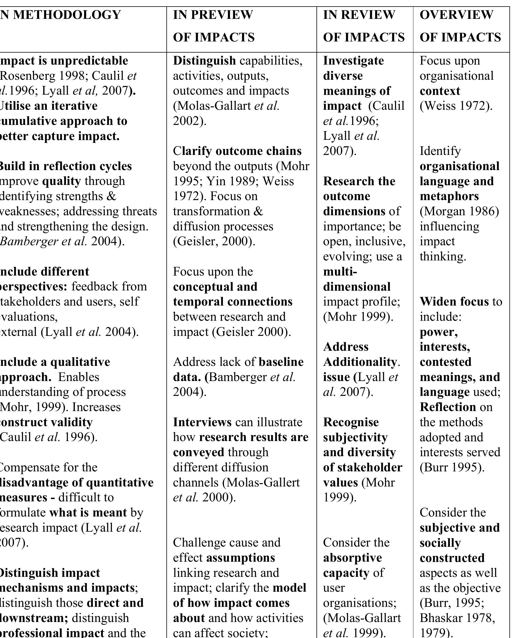
This research was funded by, and implemented within, a UK national research organisation, while the author was the KE and Impact Evaluation Manager responsible for assessing impact on a £15m UK government-funded research programme. This... more


This paper summarizes current evidence for earliest human occupation of northeastern North America during the late Pleistocene and early Holocene. We review evolution of the region's landscapes and evidence of archaeological chronologies... more
Although much has been written on the subject of ancient Mediterranean harbours, the relatively new area of harbour geoarchaeology remains dispersed in the geoscience and archaeological literature. Over a decade of research has amassed... more


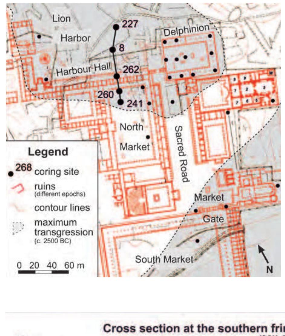
The Lion Harbour was Miletos’ most prominent harbour during antiquity. It can be envisaged as the heart of the Ionian metropolis in western Asia Minor. Originally situated in a bay of the “(I-)Karian Sea”, Miletos is now fully... more


Ancient harbour contexts have emerged as particularly novel and original archives, shedding light on how humans have interacted with and modified coastal zones since the Neolithic. Around 7,000 years ago, at the end of the post-glacial... more


Tidal flood is predicted to be more severe in the future because of sea level rise due to global warming. Purposes of the study are: 1) identify spatial distribution of tidal flood hazard in Pekalongan coastal area; 2) identify... more
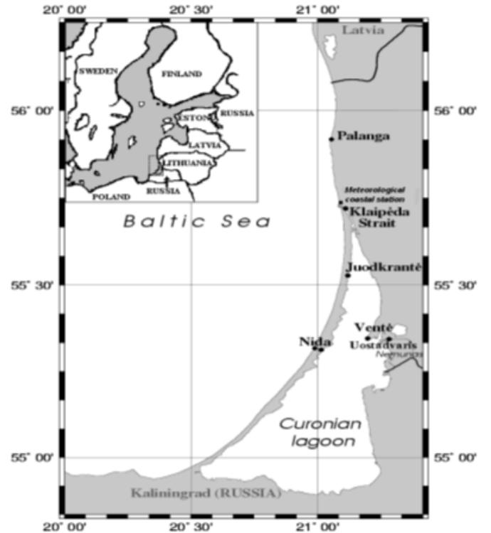
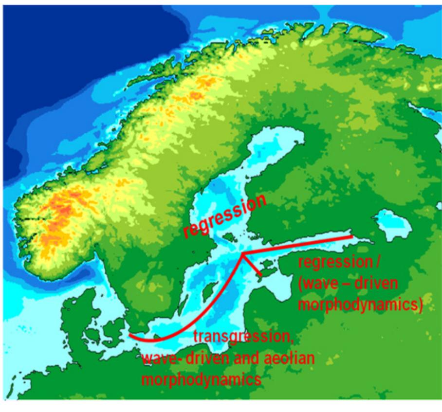
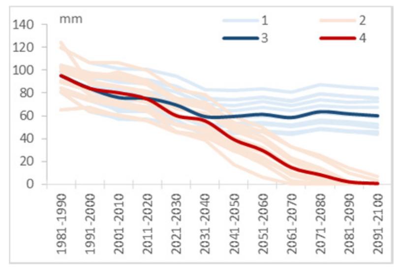
The Curonian Spit is famous for its largest man-made geomorphological feature – a distinctive foredune ridge. The main function of the foredune is to protect the coast and reduce vulnerability during the storms (Duran, Moore, 2013). To... more


![Figure 3. Change of agroclimatic areas borders over Belarus: a) agroclimatic areas borders according to A.H.Shkljar (1973) b) agroclimatic areas borders according for the period 1989-2009 c) agroclimatic areas borders according for the period 1989-2015 Agroclimatic areas: | - Northern. II - Central. II] - Southern. IV - Agroclimatic areas: | - Northern, Il - Central, Ill - Southern, IV - New.](https://figures.academia-assets.com/46859064/figure_102.jpg)
![Figure 1. Precipitation [in mm] from 18.12.-25.12. 2014 in Schleswig-Holstein. (LKN/SH & LLUR, 2015, Data Source: HydroNet, offline calibration) In the following, two exemplary activities of the BSH in the topic 1 “Adapting the transport sector to climate change and extreme weather impacts” are described.](https://figures.academia-assets.com/46859064/figure_103.jpg)


![Figure 1. Spatial pattern of water level [m NN] on 1 November 2006 over the Baltic Sea based on reconstructed model data (CoasDat-TRIM) In November 1995 and 2006 severe storm surges occurrec along the German Baltic Sea coast. Water level heights o 1.8m above sea level were observed at tide gauges ir German coastal cities as e.g. Wismar and Flensburg. Simila high water levels are reproduced by the regional ocear model TRIM-NP (Kapitza 2008) which was driven by the high-resolution atmospheric hindcast simulation o7 CoastDat (Geyer 2014) as shown for November 2006 ir Figure 1 and Figure 2. The model-based reconstructior allows information at high spatial and temporal resolution.](https://figures.academia-assets.com/46859064/figure_130.jpg)
![Intra- and interdaily variations of water level (CoastDat-TRIM):euccd3 Figure 2: Intra- and interdaily variations of water level [m NN] for selected grid boxes representing locations co-located with Flensburg, Wismar and Libeck for October and November 2006 based on reconstructed model data (CoasDat-TRIM).](https://figures.academia-assets.com/46859064/figure_131.jpg)

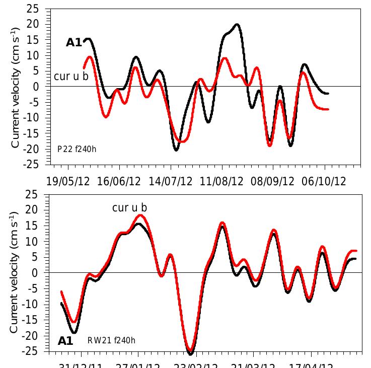
![Figure 1. The ___location of tide gauge stations in the southeastern part of the Baltic Sea. The black circles are tide gauges, used in this study; the white circles are other tide gauges, located in this region. The area of this study is the southeastern part of the Baltic Sea. The sea level variability in this area is closely related to the sea level oscillations of the whole Baltic sea. The coherence of the sea level variability in different parts of the sea decreases with increasing of oscillation frequency [Medvedev, 2015]. In this study sea level spectrum was examined in the three frequency ranges: long-term variations (including secular and seasonal sea_ level changes), mesoscale (storm surges, tides, seiches of the whole sea) and high-frequency variations (the local seiches of the lagoons). The long-term sea level variations determined by the feature of the whole Baltic Sea and adjacent waters (the North Sea). The basic factor in the formation of the low-frequency sea level variability in the Baltic Sea is the barotropic water exchange through the Danish straits. The limited throughput of these straits plays the role of a natural low-pass filter for the sea level variations: high-frequency sea level variations from the North Sea are effectively damped, while the low-frequency signal can pass through into the Baltic Sea almost undisturbed (Kulikov et al., 2015). Mesoscale sea level variability is formed inside the Baltic Sea and their scale is comparable to the scale of the entire sea. High-frequency variations are the eigen oscillations of the lagoons and bays.](https://figures.academia-assets.com/46859064/figure_133.jpg)


![two runs are displayed in Figure 1. In February, when ice appeared over the Baltic Sea, temperature values significantly vary. In ice-free months, e.g. June, both models show almost identical results. Figure 2. Differences [in Kelvin] of 2m-temperatures between two coupled COSMO-CLM/NEMO model runs: sea-surface-temperature vs. sea-surface temperaturet+sea ice-cover.](https://figures.academia-assets.com/46859064/figure_199.jpg)


![Figure 1. Annual average significant wave height [m] in reference period 1981-2010. For assessment of climatic characteristics of waves 30 year long time slices are used. The reference period is from 1981 till 2010. This is compared to distant future period 2070- 2100. Highlights of study are summarised in this abstract.](https://figures.academia-assets.com/46859064/figure_209.jpg)

![Figure 3. Absolute change in annual average significant wave height [m] between distant future 2070-2100 and reference period 1981-2010. Positive — increase of wave height.](https://figures.academia-assets.com/46859064/figure_211.jpg)


""The present study indicates that coastal geomorphology is controlled by the natural processes and anthropogenic activities. The changes in shoreline position of Udupi coast, western India, are investigated for a period of 98 years using... more


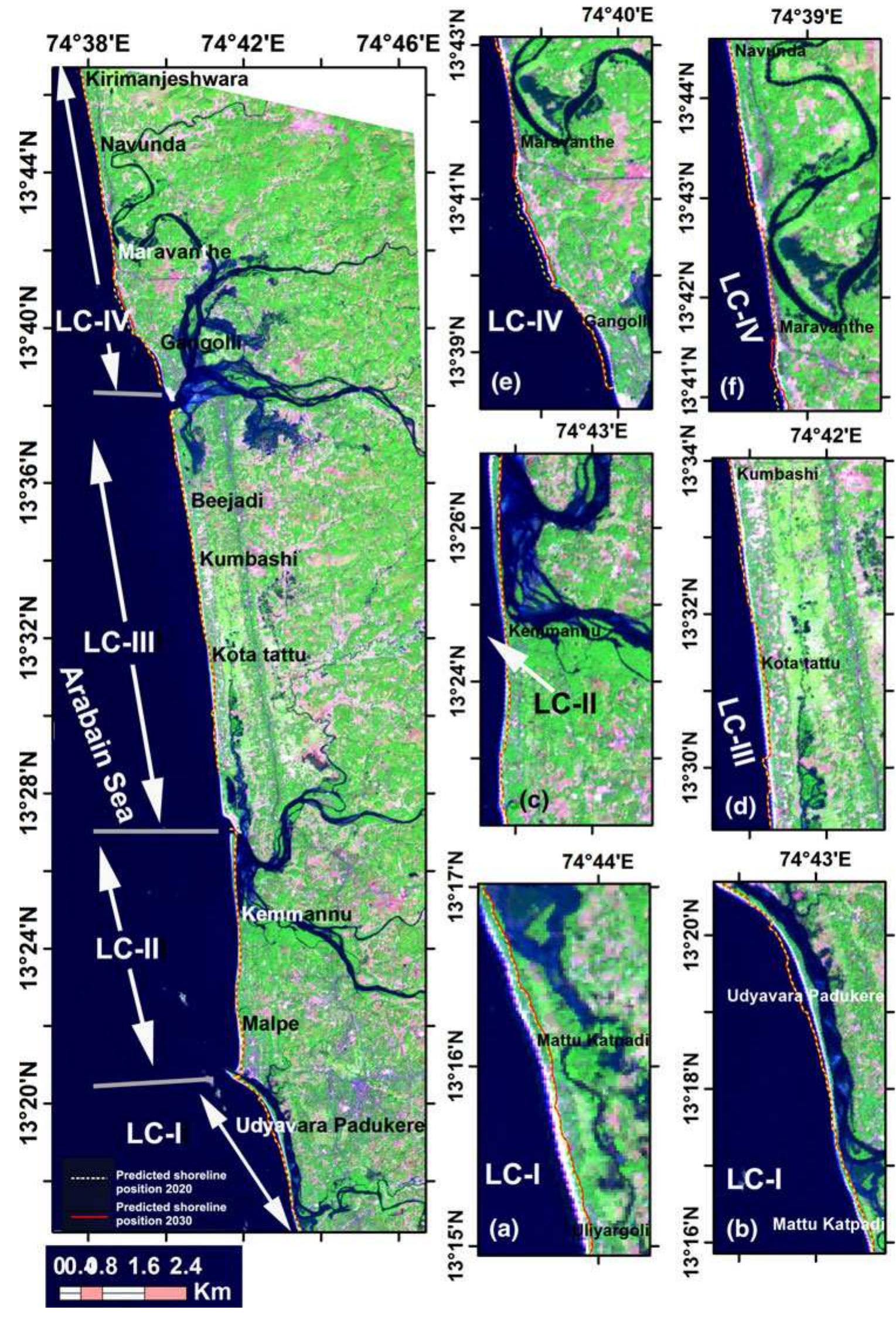

![from the shoreline; Tr3.6); d severely eroding Maravanthe beach protected by seawalls (Tr4.20) Fig. 7 a A small inlet and seawalls are observed near Kumbhashi (Tr3.21); b organic shells extraction from the beach near Bijadi (Tr3.23); ¢ sand dune in the hinterland near Saligrama (1 km away IPCC (Church et al. 2001), suggesting that the sea-level trends in the north Indian Ocean are comparable to global estimates. Over the globe, based on tide-gauge data, Douglas (2001), Church et al. (2004) and Holgate and Woodworth (2004) used reconstruction methods to determine the spatial pattern of global SLR of 1.8-2.0 mm/year during 1950-2000. These results were used to describe the regional sea-level changes and sug- gest values close to 2.0 mm/year in the north Indian Ocean, except the northeastern part of the Bay of Bengal, where values of >4 mm/year are found. The SLR varia- tions suggest that the retreat along studied section may be gradually influencing and responsible for erosion. Hence, the Udupi coast is vulnerable to accelerated SLR and the rate of erosion of this coast during 2000-2006 was 0.6018 km?/year compared to the rate of accretion and around 46 km of the coastline is under critical erosion (Dwarakish et al. 2009). side and advances landward in the down art side. Erosion/accretion is a cyclic phenomenon, which is nor- mal along this coast. Beaches along the barrier spit are subjected to erosion due to migration of rivers mouth. Construction of breakwaters in 1980s on either side of Udyavara river mouth (LC-I and -II) results in significant growth of the southern spit. The change in beach con- figuration away from this estuarine mouth is influenced by St. Mary’s group of islands situated in the offshore. Major shift of Sita-Swarna rivers mouth (LC-II and -II]) toward south by ~2.30 km is recorded for the last 98 years, due to southerly drift which is predominating over northerly drift and coastal waves are stronger than river flow. Width of K—C-H rivers mouth (LC-IV) was ~600m during 1910 has been reduced to ~380m during 2008 which has been attributed to the construction of coastal engineering structures (Gangolli harbour, breakwaters and seawalls). Uliyargoli, Padukere, Vad- abandeswara, Tonse, Kemmannu Hude, Parampalli and Kundapur Kodi are found as eroding beaches in the study area, whereas Kodi Bengre, Gangolli, Maravanthe bea- ches are highly vulnerable for erosion (Figs. 6, 7). A cumulative length of ~7km seawalls has been con- Erosion/accretion is a cyclic phenomenon, which is nor-](https://figures.academia-assets.com/31235939/figure_007.jpg)


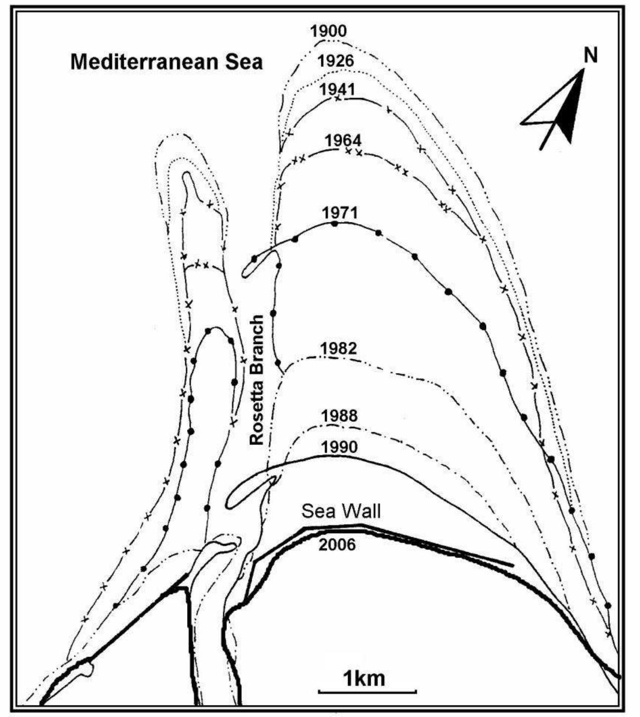
Darwish, K.; Smith, S.E.; Torab, M.; Monsef, H., and Hussein, O., 0000. Geomorphological changes along the Nile Delta coastline between 1945 and 2015 detected using satellite remote sensing and GIS. Journal of Coastal Research, 00(0),... more


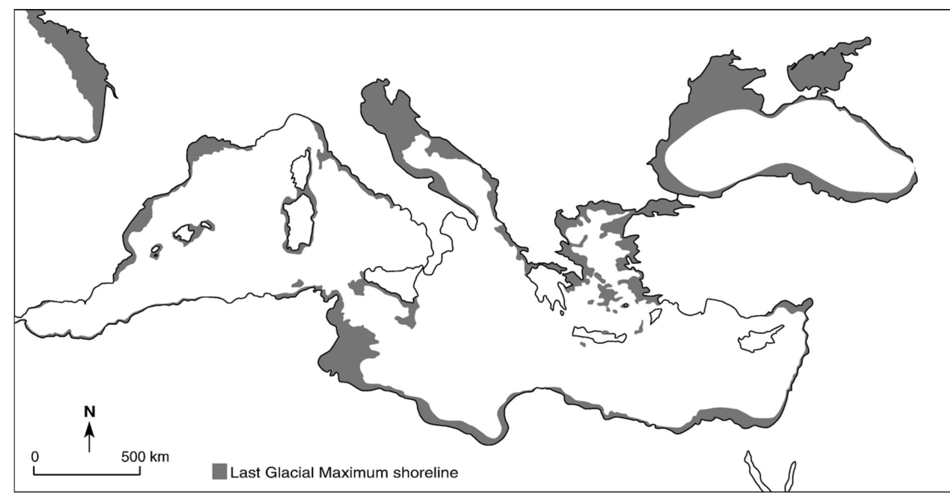
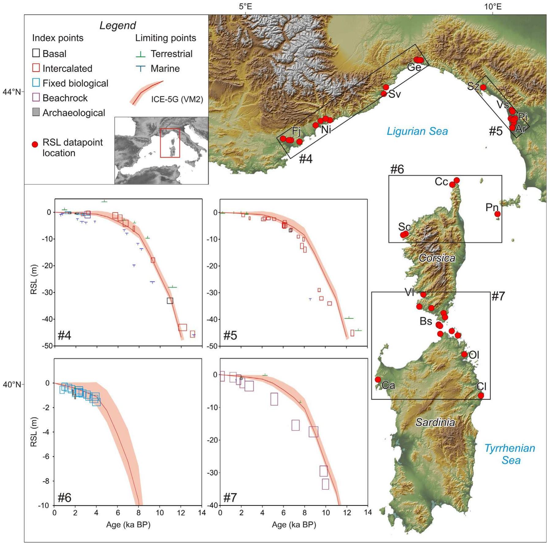
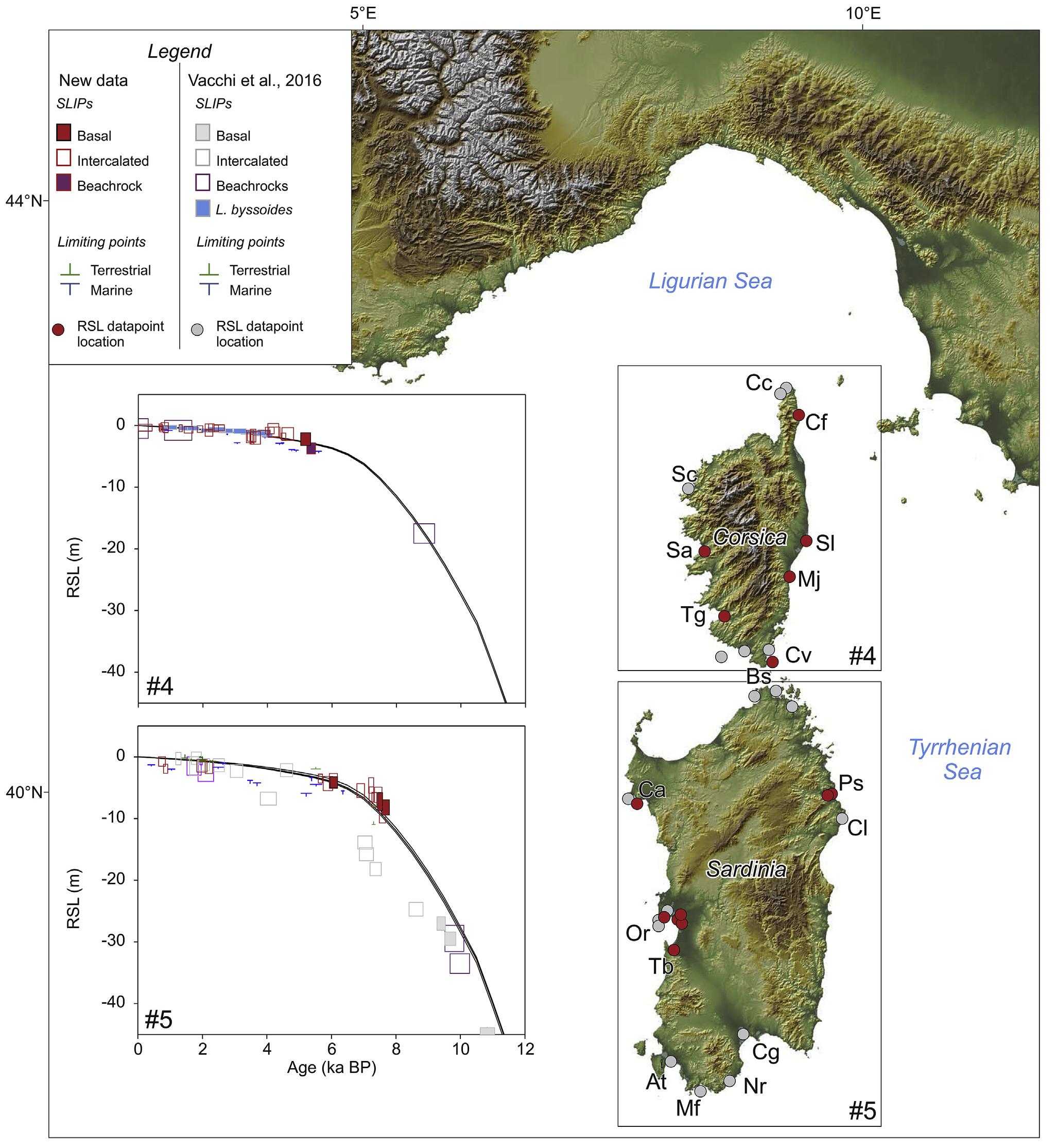
A review of 917 relative sea-level (RSL) data-points has resulted in the first quality-controlled database constraining the Holocene sea-level histories of the western Mediterranean Sea (Spain, France, Italy, Slovenia, Croatia, Malta and... more


The extant terrestrial Paleoindian sites on the Delmarva Peninsula suggest a hunting emphasis. Interpretations about Paleoindian lifestyles in the Middle Atlantic coastal plain are greatly biased by marine transgression. Research... more
In the first issue of the Journal of Island & Coastal Archaeology published 10 years ago, Erlandson and Fitzpatrick (2006) outlined eight topics which demonstrated why island and coastal archaeology were relevant to understanding a host... more


The global national situation related with Geological Heritages and Geopark possibilities in Tanzania Limestone Urban Geomorphology in Minya Governorate, Women Participation in the Nigerian Geoscience Academia The Nile valley in Minya... more


![Green Transport Solutions for Develo = i cone td Ee eae i] oy greennuncitiescom The sensors used; MSS, TM and ETM+ have varied spec- tral resolution. This presented a challenge in the comparison of Landsat images (for both siltation and LUCC). Therefore, this is an area for further studies, that is, to quantify the suspended sedi- ments within the Lake and to map the extent of land occupied by natural forest within the watersheds.](https://figures.academia-assets.com/56337544/figure_016.jpg)


![Mudlogging is surface logging which involves the ap- plication of the principles of physics to the interpretation of down hole data in correlation with the geological details obtained from the ditch cuttings coming out of the drilled hole (formation evaluation). Mudlogging operation is basi- cally carried out on a rig while drilling for oil and gas; i serves as a major tool in knowing the well condition, detec- ion of fluid influx into the well (kick), identification of oi and gas reservoir etc. It thus helps in blow out prevention and the subsequent environmental pollution that follows it. Furthermore, a typical mudlogging unit consists of severa sensors for monitoring the drilling parameters and six crew members as the case maybe. Some of the major sensors are pit sensor for monitoring the volume of mud in the pit, this helps to detect an increase or a decrease in mud volume. A sudden increase in mud volume in the active pit could be a kick and this could result in a blow out if not controlled, while a decrease could be as a result of fractured formation, hole washout or ballooning effect which could lead to loss of drilling mud. Other important sensors are the gas trap which extracts the entrapped gas coming out of the well, the flow sensors for monitoring the volume of mud flow from the wellbore, a sudden increase could be regarded as a kick. ]](https://figures.academia-assets.com/56337544/figure_029.jpg)


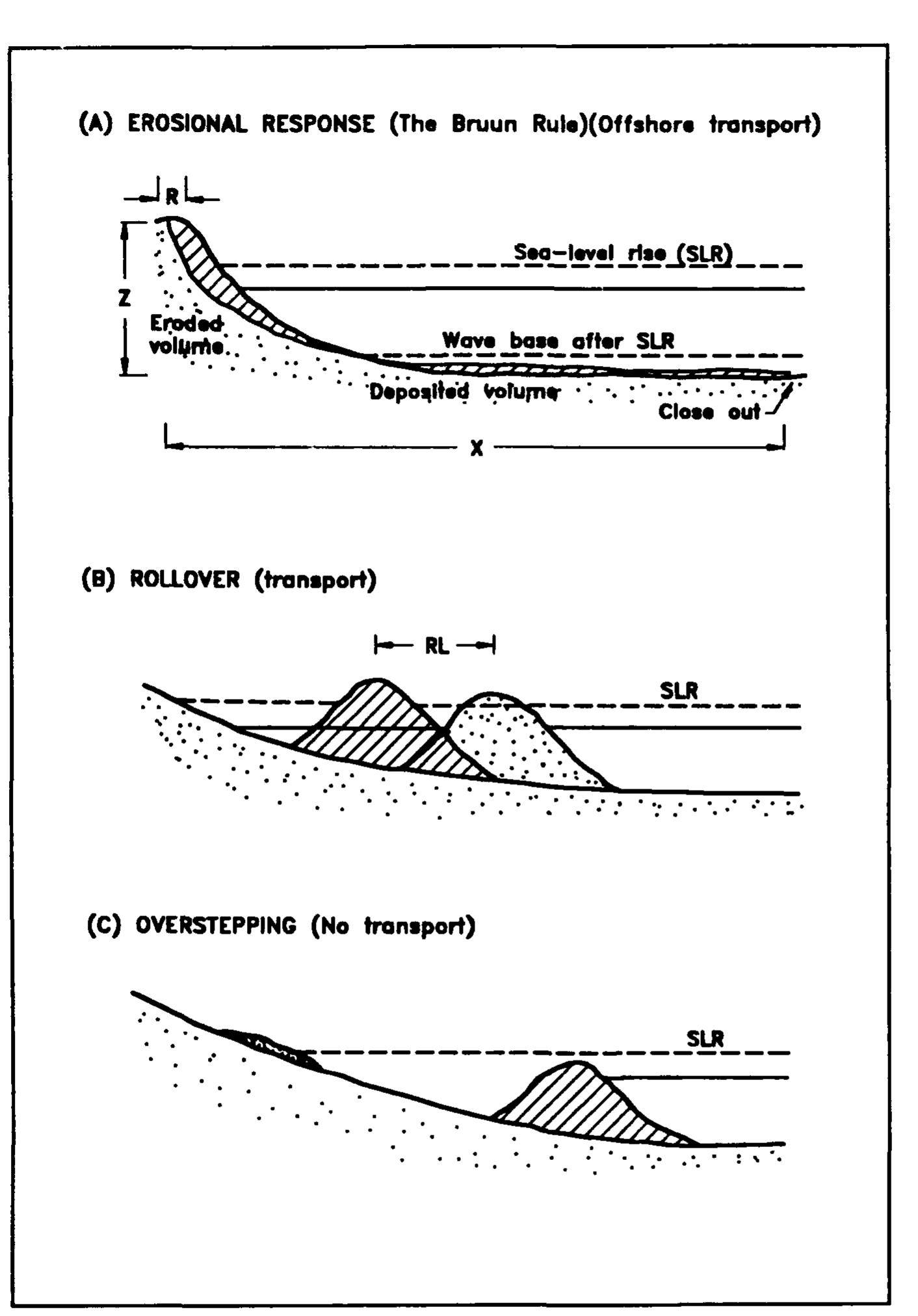
Climate change induced sea level rise (SLR) added with anthropogenically altered environment leads to rapid land dynamics in terms of erosion and accretion; and alteration in species diversity and productivity, more pronouncedly in... more
The present geomorphology of the Mediterranean’s coasts is largely a product of an intricate long-term relationship between Nature and human societies. A cradle of ancient civilizations, the Mediterranean has seen its shores occupied by... more


2018, Bivolaru A., Giaime M., Rossi V., Bottez V., Marriner N., Morhange C., Lungu V., Streinu M., Between the Danube Delta and the Black Sea. Preliminary results of a multi-proxy study of two archaeological sites (Histria and Halmyris,... more
Immagine di frontespizio Impronte umane sulla cenere dell'eruzione pliniana del Vesuvio avvenuta nel 1950 a.C. (Bronzo Antico)
Although human activity is considered to be a major driving force affecting the distribution and dynamics of Mediterranean ecosystems, the full consequences of projected climate variability and relative sea-level changes on fragile... more
ABSTRACT An early-to mid-Holocene humid phase has been identified in various Arabian geo-archives, although significant regional heterogeneity has been reported in the onset, duration and stability of this period. A multi-proxy lake and... more


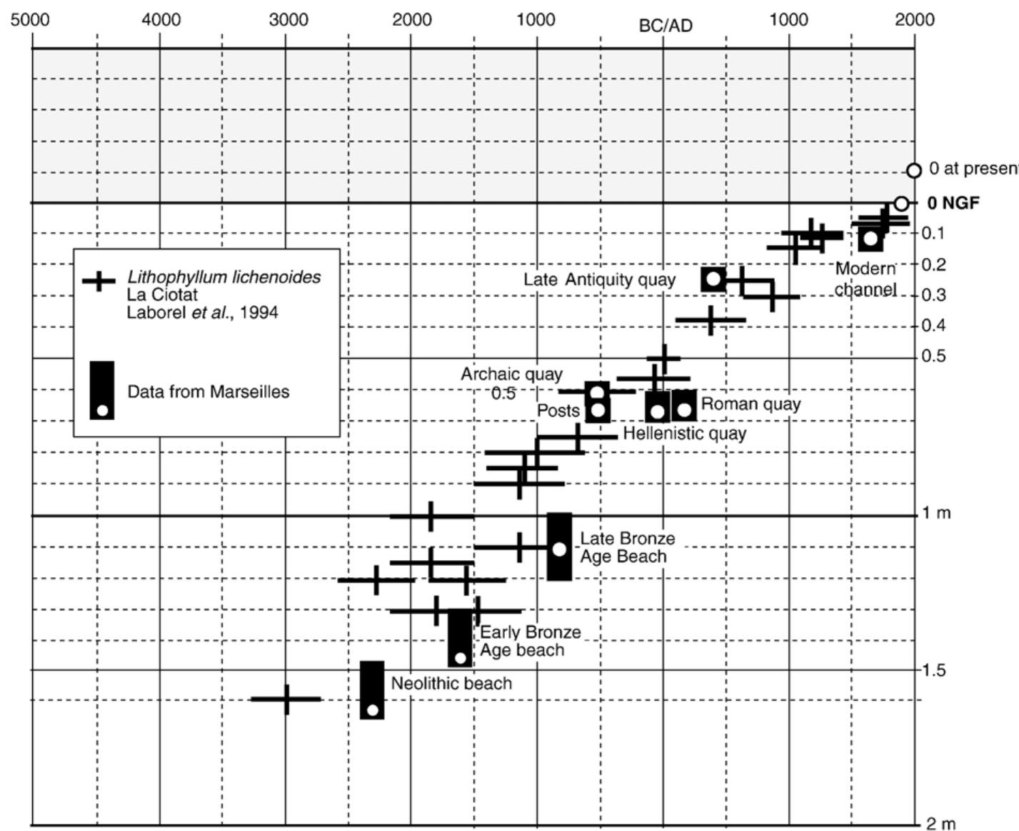
2015, Morhange C., Marriner N., Archeological and biological relative sea-level indicators, chap. 9, in Handbook of Sea Level Research, Shennan I., Long A. J., Dr Benjamin P. Horton B. P. eds, Wiley, pp. 146-156. ISBN: 978-1-118-45258-5.


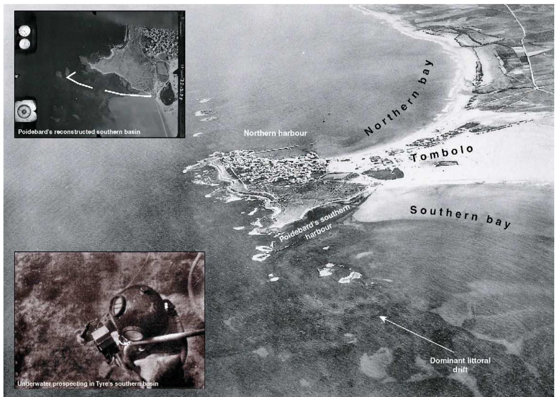
"It is generally speculated that primitive harbour dredging began during the Bronze Age along the Nile, Euphrates, Tigris and Indus rivers1. For the Roman period, Vitruvius gives a few brief accounts of dredging, although direct... more


The landscape evolution of the southern North Sea basin is complex and has left a geographically varying record of marine, lacustrine, fluvial and glacial sedimentation and erosion. Quaternary climatic history, which importantly included... more
The process of erosion and accretion taking place along a stretch of coastline is governed by the geology of the area and the direction and strength of the wave attack. The Manzanilla beach is a very dynamic system owing to the open bay... more


Coastal communities have been widely explored by various archaeological researchers, all of whom have applied and developed their own approaches to interpreting landscapes. Despite the diversity of maritime cultural studies worldwide,... more
A recent suite of Relative Sea-Level (RSL) data for the past 12 ka BP has provided new insights into the sea-level histories of the western Mediterranean region. Our analysis of the chronostratigraphic context of sea-level indicators from... more


Coastal British Columbia is largely a rugged fjord-land archipelago. It has not always been so – over time, the coastline has changed configuration dramatically and the fauna and flora have seen multiple successions and extirpations.... more


""The changes in shoreline positions and morphology of spits along the Karnataka coast, western India, are investigated for the period from 1910 to 2005 using multi-dated satellite images and topomaps. The study area has been divided into... more


Burke, Aaron A., Shelley Wachsmann, Simona Avnaim-Katav, Richard K. Dunn, Krister Kowalski, George A. Pierce, and Martin Peilstöcker. 2017. Jaffa’s Ancient Inland Harbor: Historical, Cartographic, and Geomorphological Data. In The History... more
From 2000 to 2015, tsunamis and storms killed more than 430,000 people worldwide and affected a further >530 million, with total damages exceeding US$970 billion. These alarming trends, underscored by the tragic events of the 2004 Indian... more


![Fig. 3. Location of sites and references used in this study. It is striking that the main phases of increased tsunami events in the Mediterranean fit tightly with periods of mid- and late Holocene cooling in the Northern Hemisphere (48-50). Specifically, our data fol- low the trajectory of North Atlantic climate cycles, with periods of heightened and prolonged tsunami activity corresponding to increased drift-ice transport in addition to windier and stormier conditions in the North Atlantic (51), eastern North America (52), and northwestern (NW) Europe (49). Furthermore, the deteriorating climate regime may have been amplified by reduced North Atlantic Deep Water for- mation that was concurrent with several of these cooling events (53). Significantly, we find that 90% (n = 123) of the sedimentary events interpreted as tsunamis share chronological intercepts with periods of heightened storm activity in the Mediterranean (Fig. 4). There is also significant overlap with periods of storm activity in NW Europe (49). These patterns lead us to suggest that most of the geological events previously interpreted as tsunamis could instead be attributed to periods of more intense storm activity. Because chronological overlap is not an unequivocal argument to exclude tsunami origins, we further tested this hypothesis by investigating periodicities in the historical tsunami data (figs. S2 and $3) (35). In contrast to the strat- igraphic tsunami data, the spectral, REDFIT, and wavelet analyses of the historical data present no statistically significant cycles. One further possibility when assessing these data is that climate cooling favored the generation of meteotsunamis (oceanic waves with tsunami-like charac- teristics but are meteorological in origin), which are known to occur in the Mediterranean [for example, see previous studies (54—-57)]. Al- though this is challenging to test based on the available chronostrati- graphic data, it is important to note that meteotsunamis are much less energetic than their seismic counterparts. Meteotsunamis are therefore always local, whereas seismic tsunamis can have basin-wide effects. A large meteotsunami, or one that would have the potential to leave a sedimentary record, is the result of a combination of several Cluster analyses differentiate three previously undocumented tsunami peak-and-trough couplets between 4500 cal. yr B.P. and pre- sent, with roughly 1500-year (+100 years) spacing between peaks](https://figures.academia-assets.com/54692421/figure_003.jpg)


![Fig. 6. Histogram of tsunami events at 25-year intervals, where overlapping events from the same record were attributed a score of “1” (presence) or “0” (absence). The data have been fitted using a 1500-year sinusoidal filter (in dark blue; phase = Free; r = 0.798). The more minor peaks linked to Mediterranean storm phases [in light blue; (27)] are more clearly defined.](https://figures.academia-assets.com/54692421/figure_006.jpg)


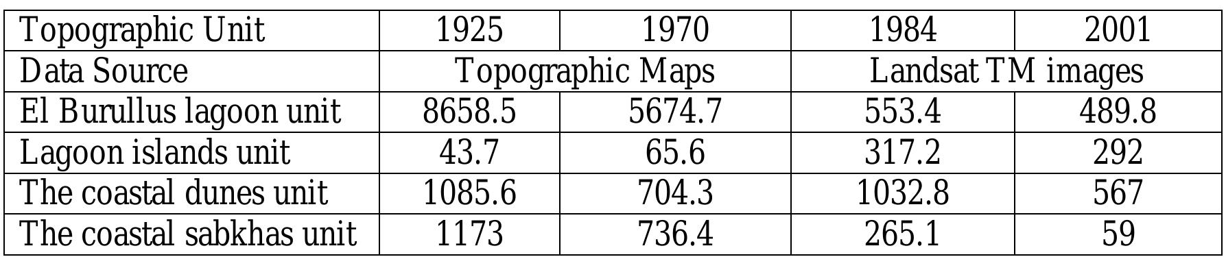
Most of the world's deltas mouths have become unstable during last century. This is because of the modern climatic changes as well as tectonic subsidence, but in case of The Nile Delta coast there is another effective reason; that is... more


The ancient harbour city of Miletus and its surroundings were affected by major changes in palaeogeography over the past millennia. These changes were due to (a) the progradation of the Büyük Menderes delta, (b) coastal dynamics as... more
![1 Palaeogeographic evolution of the Biiyiik Menderes delta and alluvial plain (Miillenhoff [2005]. slightly modified) Marc Miillenhoff, Alexander Herda and Helmut Briickner](https://figures.academia-assets.com/41064795/figure_001.jpg)


Oleh: Arif Nuf Faozi H1K014030 Pengertian Sedimen Menurut Pinkin et al. (1977) dalam Siswanto (2007) sedimen didefinisikan sebagai pecahan dari batuan, mineral, atau materi organik yang ditransportasikan dari berbagai tempat dan... more
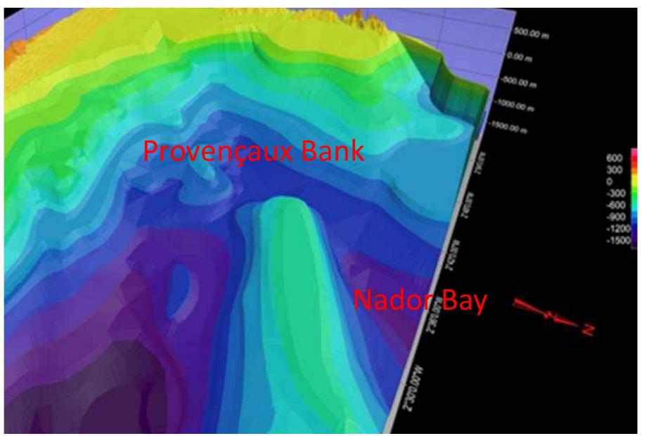
Kıyı alanları, doğal ve beşeri birçok coğrafi faktörün etkisinde olan, gelişen ve değişen bir mekândır. Kıyı alanları geçmişten günümüze, barındırdığı özellikler, çekicilikler ve sağladığı olanaklar bakımından insanların en önemli... more
GEOMORPHOLOGY AND GEOARCHAEOLOGICAL TYPOLOGY OF ANCIENT HARBOURS IN LAGOONAL CONTEXTS In coastal areas, under a context of relative sea-level stability during the past 6,000 years, one important question relates to the impact of... more
Degradasi dan kondisi pesisir di Kepulauan Bangka Belitung terancam kerusakan karena semakin maraknya kegiatan penambangan timah diperairan pesisir seperti aktivitas perusahaan tambang timah, TI(Tambang Inkovensional) apung, kapal hisap... more
2018, Pourkerman M., Marriner N., Morhange C., Djamali M., Amjadi S., Lahijani H., Naderi Beni A., Vacchi M., Tofighian H., Shah-hosseini M., Tracking shoreline erosion of “at risk” coastal archaeology: The example of ancient Siraf (Iran,... more
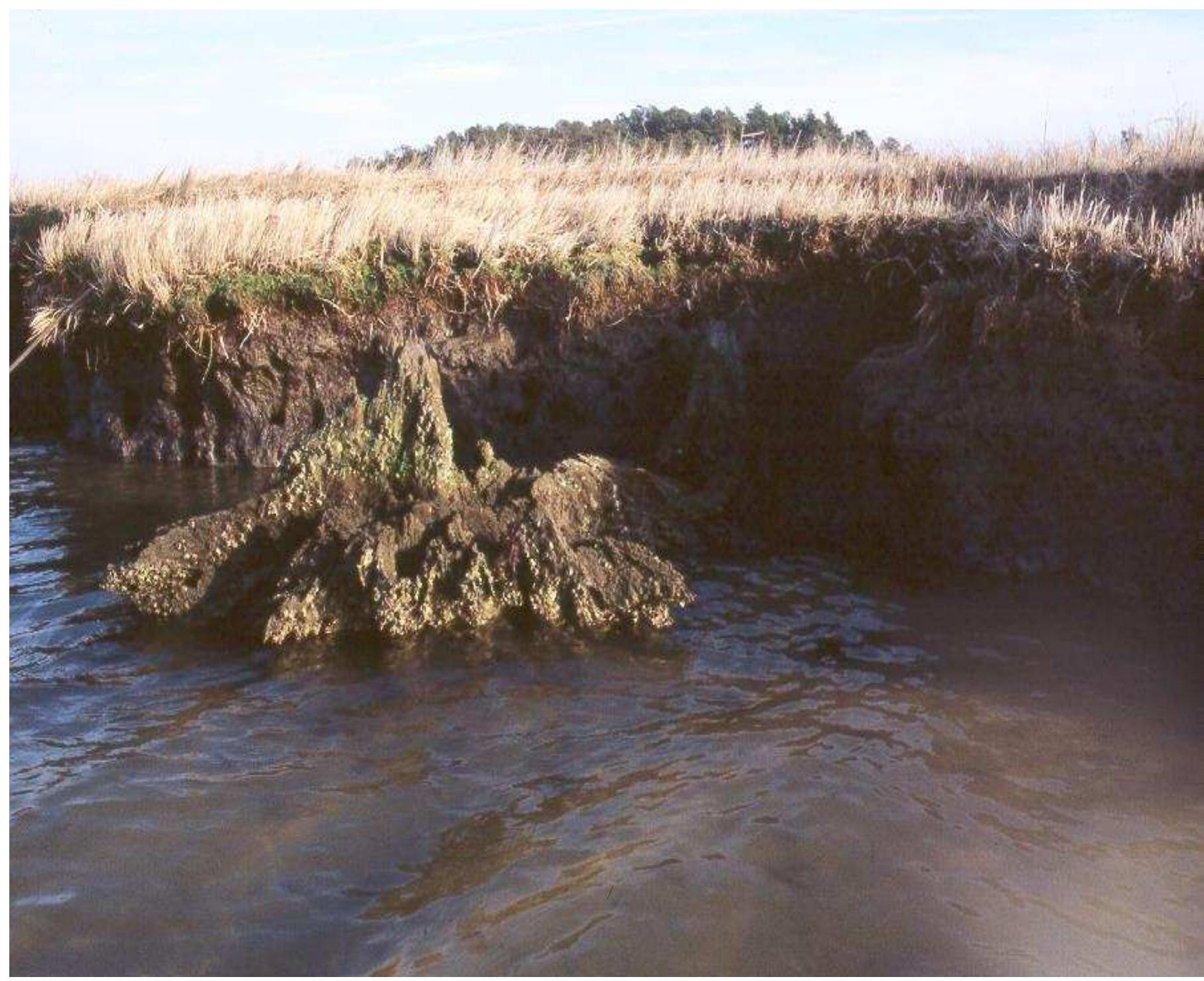
This report summarizes the results of an archaeological survey conducted along the Chesapeake Bay shorelines of both Accomack County and Northampton County, Virginia. Accomack and Northampton counties represent the southernmost extension... more


Recommandations pour les bonnes pratiques en matière
de méthodes d’acquisition de données pour la gestion du
patrimoine naturel et culturel des zones humides
côtières marocaines. CBDAMM Project: Rabat/Esbjerg 97 pp.
de méthodes d’acquisition de données pour la gestion du
patrimoine naturel et culturel des zones humides
côtières marocaines. CBDAMM Project: Rabat/Esbjerg 97 pp.
1 - The Little Ice Age : an ambiguous term 2 - Research on the LIA in the Mediterranean can be articulated around four broad questions: - What are the chronological boundaries for the beginning and the end of the LIA in the... more

Geoarchaeology. 2018. 1–20. Since the first archaeological excavations undertaken in the 1970s/1980s, Tel Akko is known to have been an important trade city from the early 2nd millennium B.C. onwards. Even if the site has been... more
![FIGURE 1 Location of Haifa Bay, on the northern limit of the Nile littoral cell (after Inman, 2003; image CNES) Notes. The rose diagrams show the dominant wind and wave patterns along the coastal margin of Alexandria (Stanley & Bernhardt, 2010) [Color figure can be viewed at wileyonlinelibrary.com]](https://figures.academia-assets.com/56839664/figure_001.jpg)
![FIGURE 2 Geomorphological map of Haifa Bay Notes. Location of the tells, the shoreline position around 4,000 years B.P., bathymetry and wave rose (measured using a directional buoy in th Haifa area between 1994 and 2005) after Zviely et al. (2006). The shoreline around 3,650 years B.P. (after Porat et al., 2008). [Color figure can be viewed at wileyonlinelibrary.com]](https://figures.academia-assets.com/56839664/figure_002.jpg)
![FIGURE 3_ Location of the cores, image CNES Notes. Squares A, B, and C correspond to the three areas studied. A corresponds to the southern part of Tel Akko; B to the western part of Tel Akko; and C to the Old City. [Color figure can be viewed at wileyonlinelibrary.com]](https://figures.academia-assets.com/56839664/figure_003.jpg)
![FIGURE 4_Biosedimentology of the core AK-XV-1 Votes. Top: Mollusk species and assemblages. Bottom: Ostracod species and assemblages. The ___location of the core is given in Figure 3. Color figure can be viewed at wileyonlinelibrary.com]](https://figures.academia-assets.com/56839664/figure_004.jpg)
![FIGURE5 _ Biosedimentology of core AK-XV-2 Notes. Ostracod species and assemblages. The ___location of the core is given in Figure 3. [Color figure can be viewed at wileyonlinelibrary.com]](https://figures.academia-assets.com/56839664/figure_005.jpg)


![FIGURE8_ East-West transect in the southern part of Tel Akko (cores AK 8 and AK 9 after Morhange et al., 2016) Notes. The ___location of the cores is given in Figure 3. [Color figure can be viewed at wileyonlinelibrary.com]](https://figures.academia-assets.com/56839664/figure_008.jpg)

![FIGURE 10 (AandC) Remains of an active sea coast; Ta, trench a; Tb, trench b; L171, level 171; L179, level 179; L219, level 219; (B) Ceramics found alongside the shell and coral fragments point to the first millennium B.C. (Artzy, 2012) [Color figure can be viewed at wileyonlinelibrary.com]](https://figures.academia-assets.com/56839664/figure_010.jpg)

![FIGURE 12 Coastline changes and ___location of Tel Akko's ancient harbors through time (adapted from Morhange et al., 2016 Notes. Topography adapted from the Treidel map (1925-1926). [Color figure can be viewed at wileyonlinelibrary.com]](https://figures.academia-assets.com/56839664/figure_012.jpg)
![FIGURE 13 __Location of ancient structures in the harbor of Akko (after Galili et al., 2010) and possible reconstruction of the harbor limits during the Hellenistic period [Color figure can be viewed at wileyonlinelibrary.com]](https://figures.academia-assets.com/56839664/figure_013.jpg)


