


The dynamic environmental history and relative sea level (RSL) changes experienced on the Northwest Coast of North America during the early post-glacial period and the early Holocene resulted in significant archaeological visibility... more
The origin and growth of blind tidal channels is generally considered to be an erosional process. This paper describes a contrasting depositional model for blind tidal channel origin and development in the Skagit River delta, Washington,... more
Publication is required by Alaska Statute 41, "to determine the potential of Alaskan land for production of metals, minerals, fuels, and geothermal resources; the ___location and supplies of groundwater and construction materials; the... more
This paper links research questions in Quaternary geology with those in Palaeolithic archaeology. A detailed geological reconstruction of The Netherlands' south-west offshore area provides a stratigraphical context for archaeological and... more

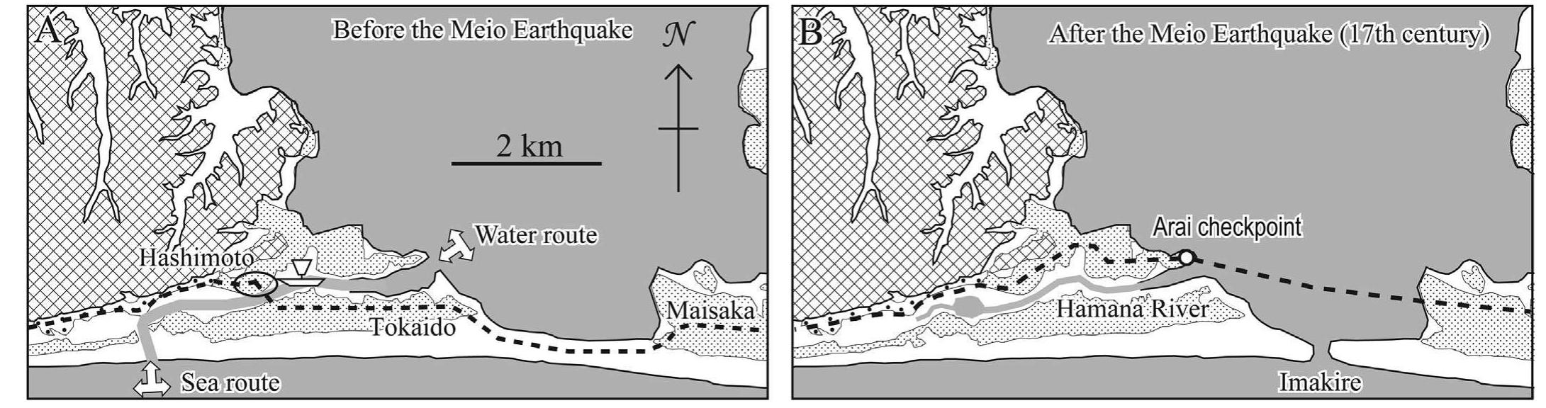
The AD 1498 Meio earthquake (M8.2∼8.4) that occurred along the eastern Nankai trough, and the tsunami generated by the earthquake, induced major geomorphological and social changes along the Pacific coast of central Japan. Geological... more


Management of highly dynamic coastal landscapes requires repeated mapping and analysis of observed changes. Modern mapping techniques such as lidar increased the frequency and level of detail in coastal surveys and new methods were... more
This report outlines the results of the academic research on historical evolution of the Ems-Dollard estuary. We analyzed the channel-bar patterns and changes in channel volume over the last 200 years and the role of resistant layers in... more
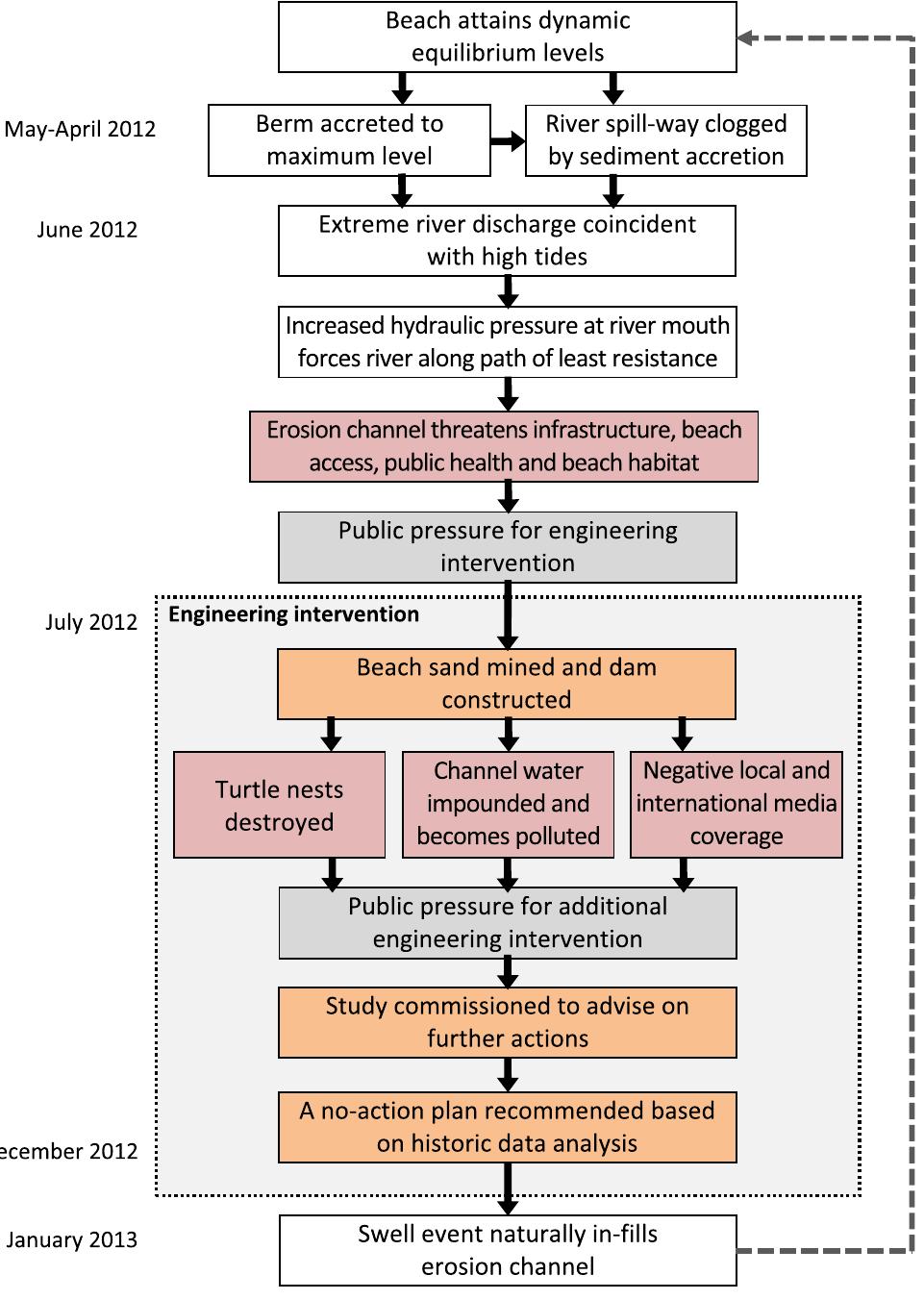
Grande Riviere beach, located on the north coast of Trinidad, West Indies, is internationally recognised as a critical habitat/nesting ground for the endangered leatherback turtles (Dermochelys coriacea). Episodic extreme flooding of the... more


Spatiotemporal patterns are difficult to portray through traditional methods, but the space-time cube allows time to be analyzed as a third dimension. The spatio-temporal GIS analysis of the MODIS data enables us to know about the varying... more
Mobilité du trait de côte et destruction des vestiges archéologiques de la façade nord‑occidentale du Cap Bon (Tunisie) Coastline mobility and destruction of archaeological remains of the north-western façade of Cap Bon (Tunisia) Mourad... more
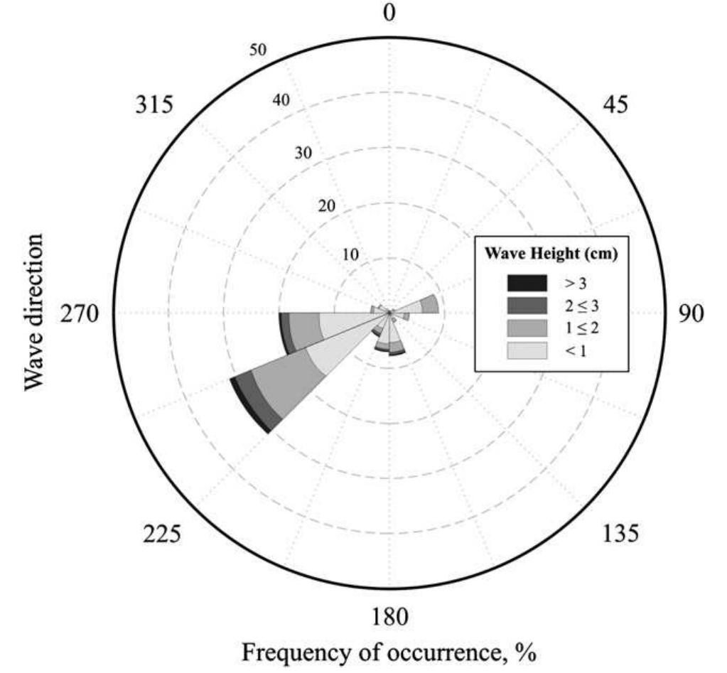
Pekalongan and Batang beach are located in the northern coast of Central Java Province. Due to the influence of Java sea wave, shoreline changes occured. This study aims to analyze the wave transformation, calculate the longshore sediment... more
The 2004 tsunami transformed the coast of Indonesia. This research investigates a sand dune area in Lampuuk, Sumatra, that was scoured by tsunami flow. We assessed geomorphology one-year post-event and examine the timescale of vegetation... more
I am very pleased that my textbook Coastal Systems is currently listed as a resource on the Cambridge International website to support learners studying AS & A Level Geography 9696. ‘Coastal environments’ is one of the Advanced Physical... more
The 560-km-long Kerala coast is characterised by long barriers with narrow beaches and steep cliffs. Distribution of cliffs from nine sections measuring a cumulative length of 63.5 km is evaluated in ArcGIS Software using topomaps and... more


![Fig. 3. Map showing section-wise ___location of cliffs and their lithology Section VII consisting of laterite and laterite with clay is a permeable cliff, extending from Neerkkadavu to Mee- nkunnu for a length of 1.5 km. Cliff sections VII and Ix extend, respectively, from Puthiyangadi to Ezhimala (4.25 km) and Pallikere to Bekal (3.75 km). Impermeable basement of these sections are overlain by semi-permeable laterites. rocky coast erode very slowly due to the constraining factors of material strength and rock mechanics (Allison 1989). Types of cliff profile and nature of their retreat differ in different locations depending on lithology, mate- rial strength, beach width and exposure to wave activity, erosive factors and recession agents. The cliff profiles are mainly slope overwall [a kind of relict cliffs found com- monly in south-west England (Lee and Clark 2002)], vertical, sigmoidal and steep convex type. Profile mor- phology of permeable cliffs is very irregular during SW monsoon season. The nature of sliding is controlled by natural (either marine or sub-aerial erosion) and anthro- pogenic (construction of jetties, groins, seawalls, digging factors of material strength and rock mechanics (Allison](https://figures.academia-assets.com/31349576/figure_003.jpg)


The most conspicuous geomorphic feature of the Sunderbans is a low, alluvial plain intersected by an intricate network of tidal rivers, creeks, estuaries and minor tidal-water courses. The Thakuran River is one of the most important tidal... more
De kustzone van Holland wordt gekenmerkt door een afwisseling van parallel aan elkaar liggende strandwallen en tussenliggende strandvlakten. Op de oude wallen liggen de geesten, voor de Hollandse kust kenmerkende akkercomplexen. Ook in de... more
Systematic shifts in shoreline position are important indicators of environmental change. Shoreline position interpreted from historical aerial imagery is frequently used to assess shoreline change. Although most published studies do not... more
L'érosion des littoraux est une réalité mondiale. Cette tendance relève en grande partie de deux facteurs : la diminution, voire la disparition dans certains cas, des apports sédimentaires à la côte, et les mouvements eustatiques.... more
Definition Coastal boundaries delimit a geographical space and are defined by the distances of one or more areas on the coast, the sea or on its interface, on the order of a few hundred meters to many kilometers, average. Coastal... more


CORTEZ, Rafael Henrique de Castro. Oceanographic characterization of a tidal inlet and the nearby coastal zone: Barra de Guaratiba inlet, Sepetiba Bay, RJ. 2014. 131 f. Dissertação (Mestrado em Oceanografia) – Faculdade de Oceanografia,... more
MASTER 2 Coastal management and vulnerabilities (COAST)
Rentrée 2020-2021
Rentrée 2020-2021
The process of erosion and accretion taking place along a stretch of coastline is governed by the geology of the area and the direction and strength of the wave attack. The Manzanilla beach is a very dynamic system owing to the open bay... more


Abstract The coastal zone of the Nile Delta is a promising area for energy resources and industrial activities. It also contains important wetland ecosystems. This coastal area witnessed several changes during the last century. A set... more


in order to define the response of the beaches to major storms that occurred during the study. Two beaches are similar, the third differs in length and in the level of protection, being less than half the length of the others and devoid... more


Substantial amounts of archaeological material have been found intermixed with beach pebbles and cobbles on the Tapes beach ridge at Longva on the island Flemsøya/Skuløya in Western Norway. The artefacts show that the beach ridge was... more


Palabras clave: geología urbana, Avellaneda, AMBA, riesgos naturales
The Wissant bay has a front shore composed of a sand coast in between cliff sections. It is affected by significant erosion that has caused the dyke that protects the seaside resort to collapse in 2000 and 2007. Such retreat of the coast... more
In het onderzoek naar de ontwikkeling en bewoning van het terpen- en wierdenlandschap is landschappelijke interesse van oudsher een belangrijke drijfveer: Hoe is het voormalige kwelderlandschap ontstaan? Hoe voorzagen mensen in hun... more
Este estudio comprende las zonas de Barú, Cartagena de Indias y Galerazamba, en el departamento de Bolívar, Colombia, y consiste en el análisis de la evolución morfodinámica de las playas de las zonas mencionadas. Estas playas fueron... more
The coastal areas of Chia and Villasimius are respectively placed in the south-west and south-east of Sardinia. These areas include sites of significant importance, from an environmental, naturalistic and landscape points of view, which... more
The coast of Galicia has more than 2.100 km for length. It is characterized by the chaining of rocky and sandy coast and it’s located in a high energy context, subject to the passage of depressions and marine storms. In the context of... more
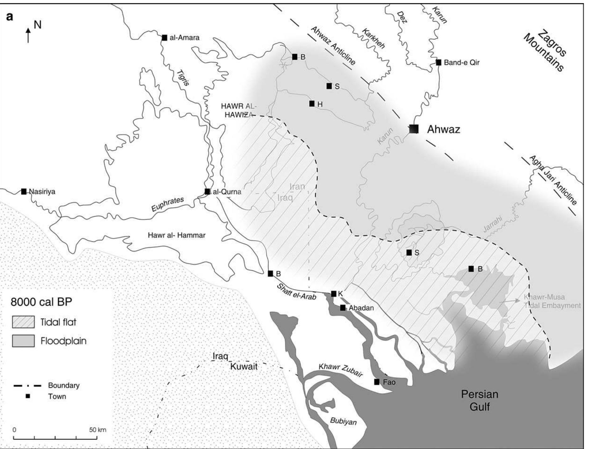
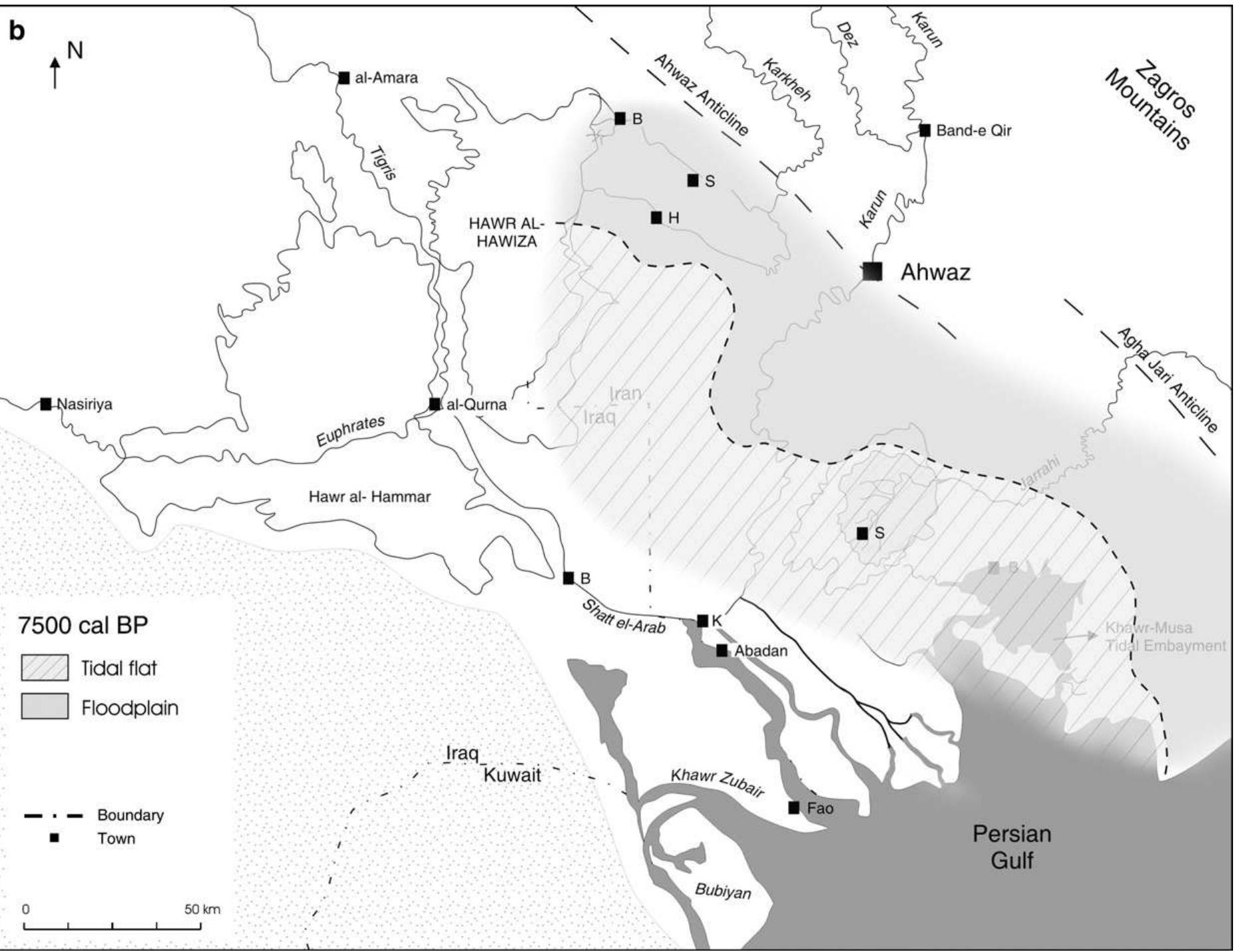
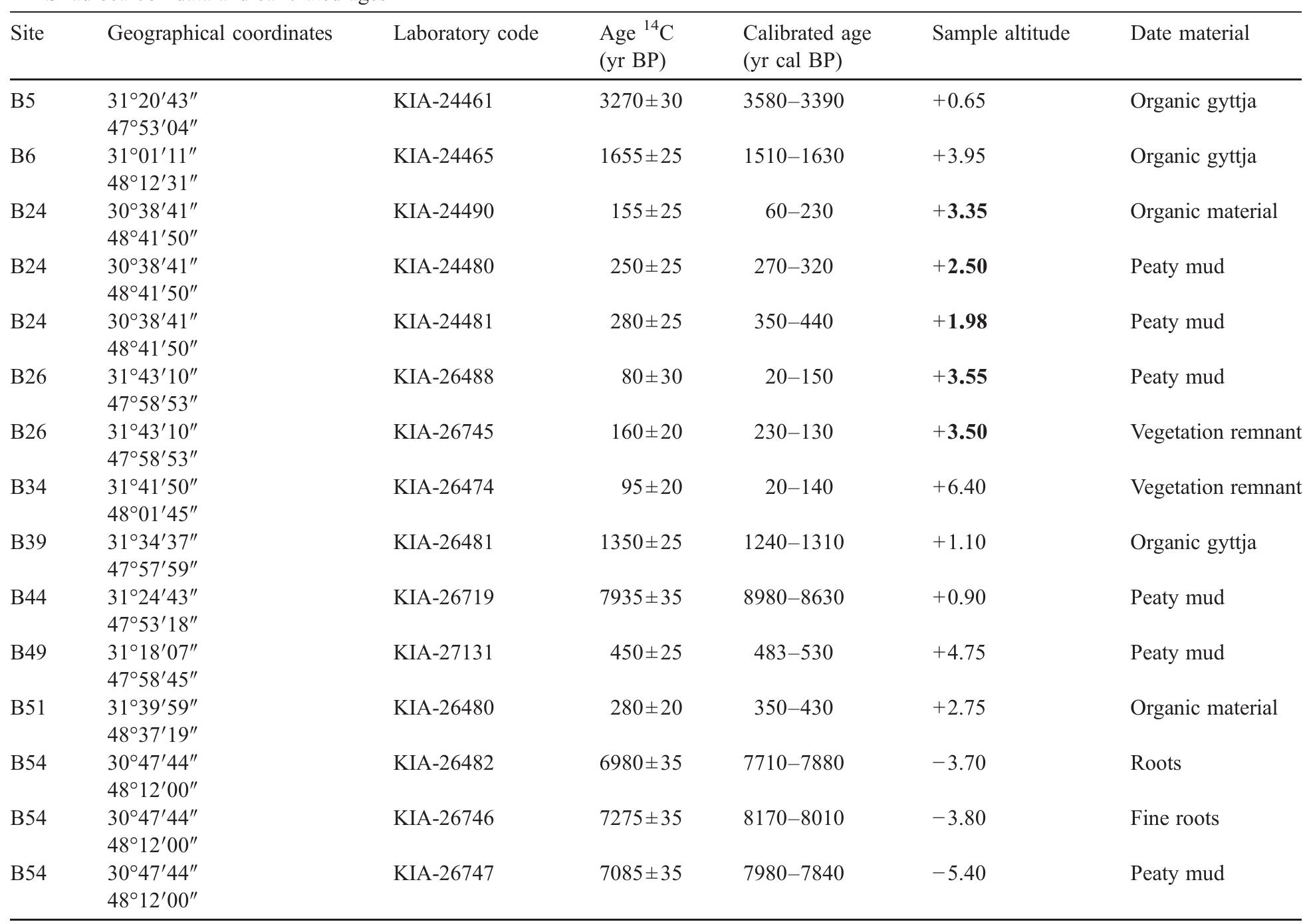
The Holocene sequence of the Lower Khuzestan plain in southwest Iran has been investigated in the context of coastal evolution and relative sea-level change. A literature review about the coastal evolution of the Shatt-el Arab region with... more


We present the results of the geomorphological mapping of a region of the Dhofar (Sultanate of Oman) including two contrasting physiographic units sharing a common drainage system into the Arabian Sea: the Jebel Qara limestone massif and... more


Coastal boulder accumulations are often mentioned in the literature, even though their interpretation remains difficult, especially along rock coasts affected both by storms and tsunamis. Studies on the geomorphic impact of such... more
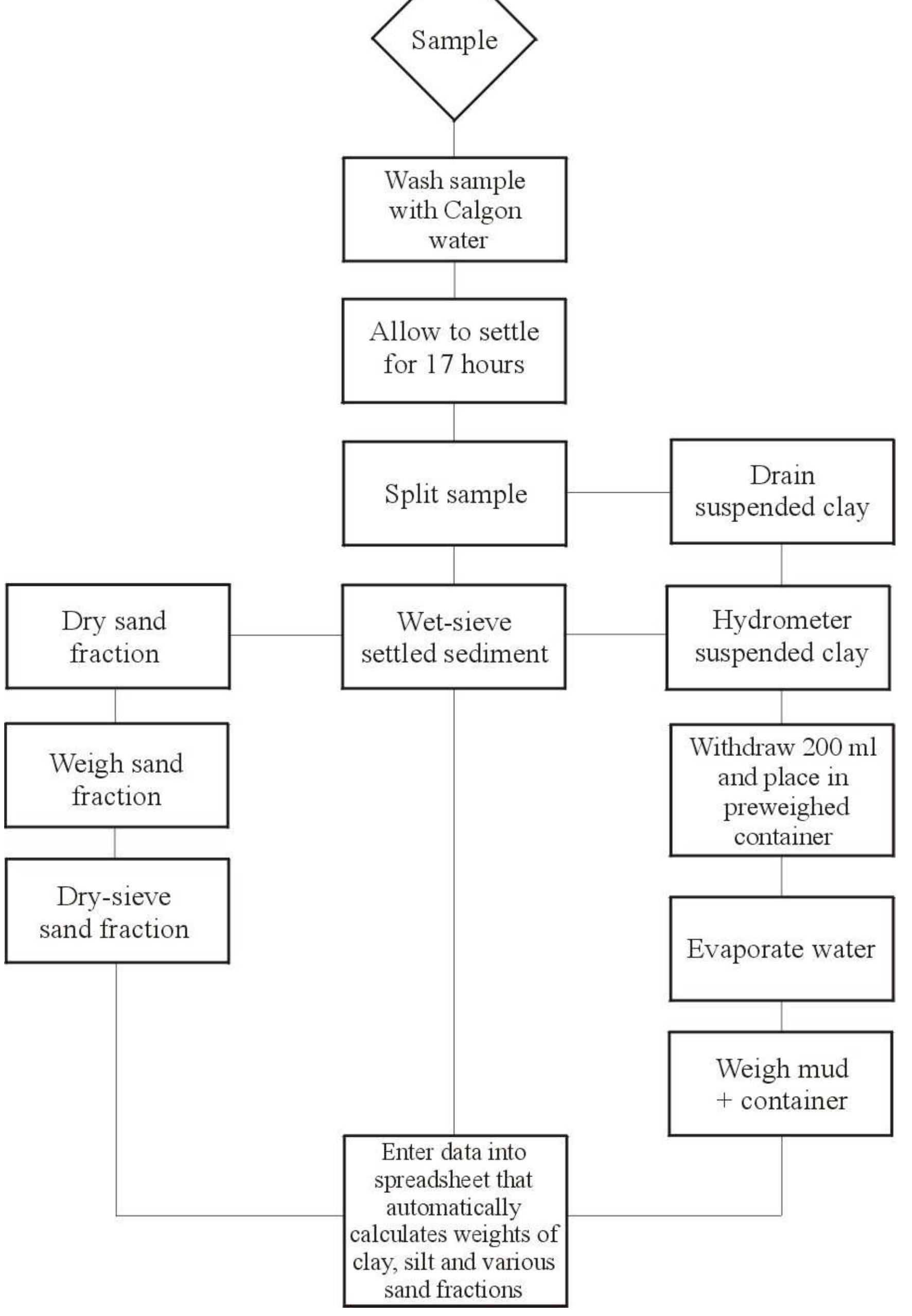
The current study begins with the premise that the archaeological record is inherently biased by processes of landscape evolution. Older archaeological deposits are frequently under-represented at the surface of the modern landscape due... more
The coastal zone is used extensively and increasingly for a large number of activities of which Ghana is not exclusive. These multiple uses are not always compatible and may result in a wide array of problems for resource users and... more
This manual describes the training process that emerged from the project and is for trainers who are involved in the training of individuals who play a role in coastal management. These individuals may be: • government officers from a... more